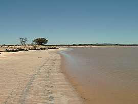
Lake Gilles, South Australia
| Lake Gilles South Australia | |||||||||||||||
|---|---|---|---|---|---|---|---|---|---|---|---|---|---|---|---|
 Lake Gilles (water body) | |||||||||||||||
 Lake Gilles | |||||||||||||||
| Coordinates | 32°57′39″S 136°44′08″E / 32.96088638°S 136.73553906°ECoordinates: 32°57′39″S 136°44′08″E / 32.96088638°S 136.73553906°E | ||||||||||||||
| Established | 2013[1] | ||||||||||||||
| Postcode(s) | 5600[1] | ||||||||||||||
| Time zone | ACST (UTC+9:30) | ||||||||||||||
| • Summer (DST) | ACST (UTC+10:30) | ||||||||||||||
| Location | |||||||||||||||
| LGA(s) | Pastoral Unincorporated Area[1][2] | ||||||||||||||
| County | Buxton[1] | ||||||||||||||
| State electorate(s) | Giles[3] | ||||||||||||||
| Federal Division(s) | Grey[4] | ||||||||||||||
| |||||||||||||||
| |||||||||||||||
| Footnotes |
Coordinates[1] Location[1] Climate[5] Adjoining localities[1] | ||||||||||||||
Lake Gilles is a locality in the Australian state of South Australia located on the Eyre Peninsula about 278 kilometres (173 miles) north west of the state capital of Adelaide and about 35 kilometres (22 miles) to the north-east of the town of Kimba.[1]
The locality was established on 26 April 2013 in respect to “the long established local name.” Its name is derived from the lake of the same name which is located within the boundaries of the locality.[1]
Lake Gilles consists of the water body known as Lake Gilles and a parcel of land to the lake's immediate south all of which is within the boundaries of the protected area, the Lake Gilles Conservation Park. Accordingly, the sole land use within the locality is conservation. The section of the Eyre Highway between Kimba in the west and Iron Knob in the east passes through the locality.[6]
Lake Gilles is located within the federal Division of Grey, the state electoral district of Giles, the Pastoral Unincorporated Area of South Australia and the state’s Far North region.[2][3][4][7]
References
- 1 2 3 4 5 6 7 8 9 "Search result for " Lake Gilles (LOCB)" (Record no SA0067214)". Property Location Browser. Government of South Australia. Retrieved 19 June 2016.
- 1 2 "Development Plan, Land Not Within a Council Area Eyre, Far North, Riverland and Whyalla – 18 October 2012" (PDF). Department of Planning, Transport and Infrastructure. 2012. pp. 11, 13, 162 & 163. Archived from the original (PDF) on 23 September 2015. Retrieved 16 September 2015.
- 1 2 "District of Giles Background Profile". Electoral Commission SA. Retrieved 20 August 2015.
- 1 2 "Federal electoral division of Grey, boundary gazetted 16 December 2011" (PDF). Australian Electoral Commission. Retrieved 20 August 2015.
- ↑ "Monthly climate statistics: Summary statistics Kimba (nearest station)". Commonwealth of Australia, Bureau of Meteorology. Retrieved 19 June 2016.
- ↑ "Eastern Eyre Peninsula Parks Management Plan" (PDF). Department of Environment, Water and Natural Resources,. 2014. pp. 3 & 4. Retrieved 1 September 2015.
- ↑ "Far North SA government region" (PDF). The Government of South Australia. Retrieved 16 August 2015.