Lake Fitri
| Lake Fitri | |
|---|---|
 | |
| Coordinates | 12°48′33″N 17°30′9″E / 12.80917°N 17.50250°ECoordinates: 12°48′33″N 17°30′9″E / 12.80917°N 17.50250°E |
| Primary inflows | Batha River |
| Catchment area | 70,000 km2 (27,000 sq mi) |
| Basin countries | Chad |
| Surface area | 500 km2 (190 sq mi) |
| Official name | Lac Fitri |
| Designated | 13 June 1990 |
| Reference no. | 486[1] |
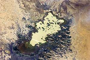
Lake Fitri is located in the center of Chad about 300 km east of N’Djamena. The normal size of the lake is about 50,000 hectares (120,000 acres). The size of this lake can triple in wetter years. This freshwater lake is shallow and is fed by seasonal rainfall and run-off from a catchment area estimated at 70,000 square kilometres (27,000 sq mi). The principal river feed is the seasonal Batha River which carries water from the Ouaddai massif to the west.
Similarly to Chad's other lake, Lake Chad, it is not quite as large as once was. It has been designated under the Ramsar Convention as a Wetland of International Importance. The normally permanent lake may dry out during severe drought periods, such as occurred at the beginning of the twentieth century and again in 1984–1985.
References
- ↑ "Lac Fitri". Ramsar Sites Information Service. Retrieved 25 April 2018.
