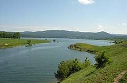
Cecita Lake
| Cecita Lake | |
|---|---|
 | |
| Location | Province of Cosenza, Calabria |
| Coordinates | 39°22′59″N 16°31′12″E / 39.383°N 16.52°ECoordinates: 39°22′59″N 16°31′12″E / 39.383°N 16.52°E |
| Type | Artificial |
| Catchment area | 154.5 km2 (59.7 sq mi) |
| Basin countries | Italy |
| Max. length | 7.5 km (4.7 mi) |
| Surface area | 12.6 km2 (4.9 sq mi) |
| Water volume | 108 hm3 (88,000 acre⋅ft) |
| Surface elevation | 1,143 m (3,750 ft) |
Cecita Lake (Italian: Lago di Cecita) is a lake in the province of Cosenza, Calabria, southern Italy.[1] It is in the northern part of the La Sila range on the western border of Sila National Park. The Mucone flows into and out of the lake. The lake is a reservoir built in 1951 by damming the Mucone. The dam is 55 metres (180 ft) high. Its purpose is to generate hydroelectricity. The dam is also used to irrigate surrounding fields, which are largely used to grow potatoes. South of the lake are Lago di Ariamacina and Botte Donato.
References
This article is issued from
Wikipedia.
The text is licensed under Creative Commons - Attribution - Sharealike.
Additional terms may apply for the media files.