Lake Burrendong
| Lake Burrendong | |
|---|---|
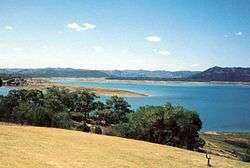 A picnic area by the lake. | |
| Location | Wellington, New South Wales |
| Coordinates | 32°40′S 149°8′E / 32.667°S 149.133°ECoordinates: 32°40′S 149°8′E / 32.667°S 149.133°E |
| Lake type | Man-made reservoir |
| Primary inflows | Macquarie River, Cudgegong River |
| Primary outflows | Macquarie River |
| Catchment area | 13,886 square kilometres (5,361 sq mi) |
| Basin countries | Australia |
| Surface area | 8,900 hectares (22,000 acres) |
| Surface elevation | 344 metres (1,129 ft) AMSL |
Lake Burrendong is a man-made reservoir created by Burrendong Dam. It impounds waters on the Macquarie and Cudgegong rivers, near Wellington, in the central west region of New South Wales, Australia.
Location and features
The waters of the Macquarie and Cudgegong rivers and Meroo Creek flow into the man-made lake, which, when full, has a capacity of approximately 1,189,000 megalitres (42,000×106 cu ft). With a catchment area of 13,886 square kilometres (5,361 sq mi) and a surface area of 8,900 hectares (22,000 acres),[1] Lake Burrendong is a popular recreation area for fishing and tourism.[2][3]
References
- ↑ "Burrendong Dam" (PDF). State Water. Government of New South Wales. Archived from the original (PDF) on 18 February 2011. Retrieved 13 April 2013.
- ↑ Swanson, Peter (2006). "Lake Burrendong - Wellington / Mumbil, NSW". Sweetwater Fishing. Sweetwater Fishing Australia. Retrieved 13 April 2013.
- ↑ "Lake Burrendong". Crown Land: State Parks. Trade & Investment NSW, Government of New South Wales. 2010. Retrieved 13 April 2013.
Further reading
- Kingsford, R.T. & Thomas, R. F. in press, The Macquarie Marshes in Arid Australia and its Waterbirds: a 50 Year History of Decline, in press, Environmental Management 19
This article is issued from
Wikipedia.
The text is licensed under Creative Commons - Attribution - Sharealike.
Additional terms may apply for the media files.