Lake Argyle
| Lake Argyle | |
|---|---|
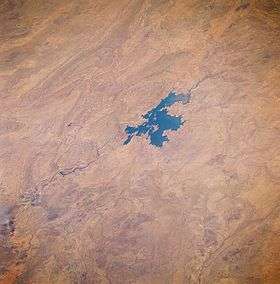 Lake Argyle seen from space, August 1985. The main channel of the Ord River (dark, meandering feature) north of the lake is visible as it drains northward, eventually emptying into the Joseph Bonaparte Gulf. Low, folded mountains can be identified east and west of this river valley. | |
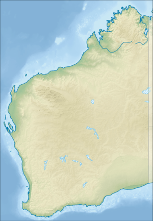 Lake Argyle Location in Western Australia | |
| Location |
near Kununurra East Kimberley, Western Australia |
| Coordinates | 16°11′19.8″S 128°54′27.4″E / 16.188833°S 128.907611°ECoordinates: 16°11′19.8″S 128°54′27.4″E / 16.188833°S 128.907611°E |
| Type | Freshwater reservoir |
| Primary inflows | Ord River, Bow River |
| Primary outflows | Ord River |
| Catchment area | 46,100 km2 (17,800 sq mi) |
| Basin countries | Australia |
| First flooded | 1971 |
| Surface area | 703 km2 (271 sq mi) |
| Water volume | 10,763 gigalitres (8.726×10⁶ acre⋅ft; 2.582 cu mi)[1] |
| References | [1] |
| Official name | Lakes Argyle and Kununurra |
| Designated | 7 June 1990 |
| Reference no. | 478[2] |
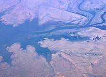
Lake Argyle is Western Australia's largest and Australia's second largest[3] freshwater man-made reservoir by volume. The reservoir is part of the Ord River Irrigation Scheme and is located near the East Kimberley town of Kununurra. The lake flooded large parts of the Shire of Wyndham-East Kimberley on the Kimberley Plateau about 80 kilometres (50 mi) inland from the Joseph Bonaparte Gulf, close to the border with the Northern Territory.
The primary inflow is the Ord River, while the Bow River and many other smaller creeks also flow into the dam. The lake is a DIWA-listed wetland.[4] as it is the largest lake in northern Australia and an excellent example of a man-made lake. Additionally Lake Argyle, along with Lake Kununurra, are recognised as a Ramsar protected wetlands and were listed in 1990 as Australian Site Number 32.[5]
History and construction
The traditional owners are the Miriwoong Gajerrong peoples who have inhabited the area for thousands of years and knew the Ord river as Goonoonoorrang.[6] The dams were built with no consultation with or compensation to the Indigenous traditional owners.[7]
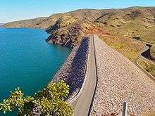
The construction of the Ord River Dam was completed in 1971 by the American Dravo Corporation.[8] The dam was officially opened the following year. The dam wall is 335 metres (1,099 ft) long, and 98 metres (322 ft) high. The earth-fill only dam wall at Lake Argyle is the most efficient dam in Australia in terms of the ratio of the size of the dam wall to the amount of water stored. The lake was named after the property it partly submerged, Argyle Downs.[8]
Ord River Dam post office opened on 1 March 1969 and closed on 15 November 1971 demonstrating the approximate duration of the construction camp.[9]
In 1996, the spillway wall was raised by 6 metres (20 ft), which doubled the dam's capacity.[10] Sediment flowing into the dam caused concerns in the mid-1990s that the dam's capacity could be dramatically reduced. By 2006 continual regeneration of the upper Ord catchment appeared to have reduced the amount of sediment inflow.[11]
Water supply
Lake Argyle normally has a surface area of about 1,000 square kilometres (390 sq mi). The storage capacity, to the top of the spillway is 10,763 gigalitres (3.801×10¹¹ cu ft). The lake filled to capacity in 1973, and the spillway flowed until 1984. Lake Argyle's usual storage volume is 5,797 gigalitres (2.047×10¹¹ cu ft),[12] making it the largest reservoir in Australia. The combined Lake Gordon/Lake Pedder system in Tasmania is larger but is two dams connected by a canal. At maximum flood level, Lake Argyle would hold 35,000 gigalitres (1.2×10¹² cu ft) of water and cover a surface area of 2,072 square kilometres (800 sq mi).[8]
Lake Argyle, together with Lake Kununurra, is part of the Ord River Irrigation Scheme. There are currently some 150 square kilometres (58 sq mi) of farmland under irrigation in the East Kimberly region. The original plan was for dam water to irrigate rice crop for export to China.[8] However these plans were scuttled as waterfowl, particularly magpie geese ate rice shoots quicker than they could be planted. Other crops are now grown, but Lake Argyle still remains Australia's most under-utilised lake.[8]
Flora and fauna

The damming of the Ord River has caused major changes to the environment. Flows to the Ord River have been severely reduced. Within Lake Argyle itself a thriving new eco-system has developed. The lake is recognised as an important wetland area under the Ramsar Convention; with Lake Kununurra it forms the Lakes Argyle and Kununurra Ramsar Site.[13]
The lake is now home to 26 species of native fish and a population of freshwater crocodiles currently estimated at some 25,000.[14] Fish species that are present in Lake Argyle include barramundi, southern saratoga, archer fish, forktail cat fish, mouth almighty, long tom, bony bream and sleepy cod.[8] While the official website states that only incidentally a saltwater crocodile is found,[15] other experts disagree.[16]
Cane toads reached the dam in late 2008, mostly via traveling along the Victoria Highway, with numbers rising significantly during the 2009 summer.[13]
Birds
The lake, with its surrounding mudflats and grasslands, has been identified by BirdLife International as an Important Bird Area (IBA) because it supports about 150,000 waterbirds with twelve species being represented in large enough numbers to be considered internationally significant. The mud flats and grasslands are the natural habitat of eight wader species also represented in internationally significant numbers, along with a healthy population of Australian bustards which are considered a near threatened species. Birds for which the lake has global importance include magpie geese, wandering whistling-ducks, green pygmy-geese, Pacific black ducks, hardheads, black-necked storks, white-headed stilts, red-capped plovers, Oriental plovers, black-fronted dotterels, long-toed stints and sharp-tailed sandpipers.[17]
Common larger-bodied bird species found at the lake include the Australian pelican, black swan, eastern great egret, royal spoonbill, osprey and wedge-tailed eagle. Common smaller-bodied bird species include the spinifex pigeon, peaceful dove, common sandpiper, white-winged tern and budgerigar, while mid-sized bird species include the red-winged parrot, blue-winged kookaburra and barking owl.[17]
Some threats identified by the IBA include invasive weed and animal species, such as the cane toad, as well as agricultural uses, free range cattle and feral ungulates that may be over-grazing in the shallow areas around the lake. The IBA recommends that a fence be installed in the important shallows in the south and east to prevent all ungulates from entering those lake areas.[17]
See also
- List of reservoirs and dams in Western Australia
- Water security in Australia


References
- 1 2 WA - Water Corporation Archived 2008-02-04 at the Wayback Machine.
- ↑ "Lakes Argyle and Kununurra". Ramsar Sites Information Service. Retrieved 25 April 2018.
- ↑ "Largest Waterbodies". Geoscience Australia. Retrieved 15 March 2015.
- ↑ "Search for a Nationally Important Wetland". 2010. Retrieved 6 June 2010.
- ↑ "Australian Ramsar Sites - Lake Argyle and Kununurra". 2010. Retrieved 6 June 2010.
- ↑ Vanessa Mills (10 February 2011). "How Kununurra got its name". Australian Broadcasting Corporation. Retrieved 24 September 2018.
- ↑ "Lessons from the Kimberley on developing Northern Australia". The Conversation. 21 July 2014. Retrieved 24 September 2018.
- 1 2 3 4 5 6 Harrison, Rod; Ernie James; Chris Sully; Bill Classon; Joy Eckermann (2008). Queensland Dams. Bayswater, Victoria: Australian Fishing Network. pp. 60&mdash, 61. ISBN 978-1-86513-134-4.
- ↑ Premier Postal History, Post Office List, retrieved 21 January 2016
- ↑ Willacy, Marck (12 November 2006). "Fears for second stage of Ord Irrigation Scheme". Landline. Australian Broadcasting Corporation. Retrieved 15 May 2009.
- ↑ "Dept hopes sediment flow into Lake Argyle will decrease". ABC News online. Australian Broadcasting Corporation. 11 December 2006. Retrieved 15 May 2009.
- ↑ Australian Govt. Pub. Service Ord River Irrigation Area review. a joint Commonwealth and Western Australian review. 1979
- 1 2 Narelle Towie (11 May 2009). "Cane toads thrive in Lake Argyle". PerthNow. The Sunday Times. Retrieved 15 May 2009.
- ↑ Claudia Bertorello-Kell (3 June 2007). "Argyle racers shrug off crocs". PerthNow. The Sunday Times. Retrieved 15 May 2009.
- ↑ "Freshwater Crocodiles (Crocodyllus Johnstoni)". Lake Argyle. Archived from the original on 19 August 2010. Retrieved 31 March 2010.
- ↑ Bennett, Michael (27 March 2010). "Fatal crocodile attack 'inevitable'". The West Australian. Retrieved 31 March 2010.
- 1 2 3 "IBA: Lake Argyle". Birdata. Birds Australia. Archived from the original on 2011-07-06. Retrieved 2011-07-18.