Laja River (Chile)
| Laja River | |
|---|---|
 | |
| Country | Chile |
| Physical characteristics | |
| Main source | Laguna del Laja |
| River mouth | Biobío River |
| Length | 140 km (87 mi)[1] |
| Basin features | |
| Basin size | 4,040 km2 (1,560 sq mi)[1] |
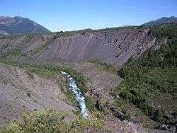
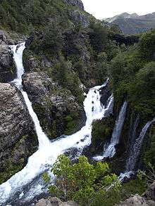
Laja River (Spanish: Río De La Laja) is a river in Chile, along which can be found the Laja Falls. It is located in the Bío Bío Region. The source of the river is Laguna del Laja in the Andes, then flows westward through the Chilean Central Valley and terminates into the Bío Bío River, being an important tributary of it.
Whitewater
The Laja River is known among whitewater kayakers in Chile as Class 5 very steep and thrilling whitewater kayaking run. The Laja river actually forms from a drainage in the Lake Laja where the water exits at the bottom of the lake through the side of a mountain. Because the river is formed from exiting the bottom of the lake the river level is always constant.[2]
Hydropower
Three hydropower plants are located at and below the outlet of Lake Laja, including the 400 MW El Toro Hydroelectric Plant built in 1973 and the 300 MW Antuco Hydroelectric Plant built in 1981.
Irrigation
Below the lake and the hydropower plants and before the Laja Falls lie 70,000 hectares of irrigated land.[3]
History
In 1984, private companies planned to divert the Laja River to another river further north to power new hydroelectric plants there. Opponents argued that the interbasin transfer would dry up the Laja Falls and would increase pollution in the lower Biobío River, because the Laja River diluted the pollution from the upper BíoBío River and pollutant would be more concentrated in the absence of this dilution. Irrigators also feared their water rights would be affected. Although the Supreme Court rejected a lawsuit against the transfer, it was eventually considered to be too controversial politically and was abandoned.[3]
References
- 1 2 Niemeyer, Hans (1980). "Hoyas hidrográficas de Chile. Octava Región". Ministerio de Obras Públicas. Dirección General de Aguas. Retrieved 2012-03-16.
- ↑
- 1 2 Bauer, Carl J. (2004). "The Siren Song: Chilean Water Law as a Model for International Reform". Resources For the Future. pp. 100–103. Archived from the original on 2009-08-04. Retrieved 2009-06-24.
| Rivers |  | |
|---|---|---|
| Waterfalls |
| |
| Lakes | ||