Lahugala
| Lahugala ලාහුගල லகுகலை | |
|---|---|
| Town | |
 Lahugala | |
| Coordinates: 6°52′41.3″N 81°43′12.1″E / 6.878139°N 81.720028°ECoordinates: 6°52′41.3″N 81°43′12.1″E / 6.878139°N 81.720028°E | |
| Country | Sri Lanka |
| District | Ampara District |
| Time zone | UTC+5:30 (SLST) |
| Postal code | 32512[1] |
Lahugala (Sinhalese: ලාහුගල, Tamil: லகுகலை) is a small town in Ampara District, Eastern Province of Sri Lanka. The town is located on Colombo-Batticaloa main road approximately 14 km (8.7 mi) away from Pothuvil town.
History
Lahugala area was an ancient populated place in Sri Lanka since Anuradhapura era and was a part of the Kingdom of Ruhuna. A number of ancient ruined sites located in and around the area prove the long history of Lahugala. Most of these sites found in the area is said to be belonged to the royal family of King Mahanaga.[2]
Education
The government owned schools in Lahugala division are listed below.[3]
- Panama Maha Vidyalaya.
- Lahugala Maha Vidyalaya.
- Hulannuge Vidyalaya.
- Paranagovipola Vidyalaya.
- Government Tamil mixed school.
- viharamahadevi vidyalaya
Tourist attractions
- Lahugala Kitulana National Park, was declared a national park on 1 October 1980 and is one of the smallest national parks in Sri Lanka. Despite its land area, the park is considered as an important habitat for Sri Lankan elephants.[5]
- Magul Maha Vihara, is an archaeologically protected Buddhist temple in Lahugala, built by King Kavanthissa in the 2nd Century BC. The temple lies on the northern edge of the Lahugala National Park. The famed moonstone with a mahout on the elephant can be seen in the temple.[6]
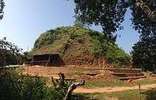
- Neelagiriseya, is an ancient Buddhist Stupa which is believed to have been built by either King Kawantissa (3rd Centaury BC) or King Bhatikabaya (20 BC-9 AC).
- Lahugala Kota Vehera, is one of four ancient Stupas belonging to the Kota Vehera style in the country.[7]
- Lahugala Kiri Vehera, is an old Vihara, located in Lahugala. Currently this temple has been protected as one of archaeological protected sites in Sri Lanka.
References
- ↑ "Lahugala". sri-lankan.net. Retrieved 17 January 2017.
- ↑ "Overview". Lahugala divisional secretariat. 8 April 2016. Retrieved 17 January 2017.
- ↑ "Schools". Lahugala divisional secretariat. 8 April 2016. Retrieved 17 January 2017.
- ↑ "Conservation Neelagiri Maha Seya". Office of the Cabinet of Ministers. 12 January 2011. Retrieved 26 December 2016.
- ↑ "Lahugala Kitulana National Park". www.angelfire.com. Retrieved 17 January 2017.
- ↑ "Lahugala Magul Maha Viharaya – ලාහුගල මගුල් මහා විහාරය". Amazinglanka. Retrieved 17 January 2017.
- ↑ "Lahugala Kota Vehera – ලාහුගල කොටවෙහෙර". Amazinglanka. Retrieved 17 January 2017.
External links
This article is issued from
Wikipedia.
The text is licensed under Creative Commons - Attribution - Sharealike.
Additional terms may apply for the media files.