Laguna Seca (Santa Clara County)
| Laguna Seca | |
|---|---|
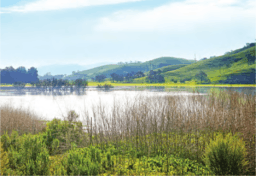 Laguna Seca is the largest freshwater lake and wetland in Santa Clara County. | |
 Laguna Seca | |
| Location | Santa Clara County, California, United States |
| Coordinates | 37°12′46″N 121°45′20″W / 37.2127224°N 121.7555049°WCoordinates: 37°12′46″N 121°45′20″W / 37.2127224°N 121.7555049°W |
| Basin countries | United States |
| Surface elevation | 243 ft (74 m)[1] |
Laguna Seca is a seasonal lake located in south Santa Clara Valley in the Coyote Valley, an area critical to wildlife as the narrowest corridor connecting Mt. Hamilton and the Diablo Range on the east to the foothills of the Santa Cruz Mountains to the west.[1] It is the largest freshwater wetland in Santa Clara County, California and is fed by Fisher Creek.[2] A man-made channel extends Fisher Creek to Coyote Creek.
History
The first written historical account of La Laguna Zeca 'the dry lake' was first described on 31 October 1797.[3]
Rancho Laguna Seca (Alvires) or Refugio de la Laguna Seca is a Mexican land grant presumably named for the seasonal lake. The grant was made July 22, 1834 to Juan Alvires by Governor José Figueroa.[4]
Historically, Laguna Seca was an approximately 1,000-acre spring-fed perennial wetland mosaic of flooded wet meadows and smaller perennial freshwater marshes and lagunas. It occasionally dried up in drought years. From 1916 to 1917, Laguna Seca was largely filled in to permit agriculture.[5]
Geology and ecology
The remnants of Laguna Seca are bordered by and west of Santa Teresa Boulevard, located at the north end of the area now known as Coyote Valley at the base of the saddle between Tulare Hill[6] and the Santa Teresa Hills.[7] The marshes and lagunas formed as the bedrock of the Santa Teresa Hills forced groundwater to the surface and drainage was blocked by the natural levees of Coyote Creek. In addition, the heavy clay soils characteristic of the bottomland areas, often referred to as “black adobe” soils, often forced groundwater to the surface as springs and seeps.[5] The lake helps recharge the aquifer in the Coyote Valley. Laguna Seca could provide major flooding protection to downstream San Jose, if the man-made extension of Fisher Creek from Laguna Seca to Coyote Creek was removed. It has been shown that Fisher Creek currently contributes approximately 57% of peak flows that exceed channel holding capacity during a 10-year flooding event at William Street in downtown San José and that hydrologic restoration projects designed to spread, capture, and sink excess stormwater in the Coyote Valley could reduce the risk of flooding to downstream areas while also recharging Coyote Valley’s groundwater sub-basin (Robins 2016).[8]
Today the waters of Laguna Seca are ponded above the surface December to May, but near the surface all year-round.[9] It hosts endangered amphibian species such as the California tiger salamander (Ambystoma californiense) and the California red-legged frog (Rana draytonii). It is also an important stopover for migrating waterfowl.[2]
Potential restoration of Laguna Seca provides an unusual opportunity to restore natural wetland functions and a diverse, large, natural, valley floor wetland. Successful wetland restoration at Laguna Seca could support a wide range of threatened species, including rare plants, amphibians, and water birds.[5]
See also
References
- 1 2 "Laguna Seca (historical)". Geographic Names Information System. United States Geological Survey.
- 1 2 Julie Phillips; Ryan Phillips; Neela Srinivasan; Deborah Aso; Wendy Lao; Pat Cornely (2012). Safe Passage for Coyote Valley: A Wildlife Linkage for the 101 Corridor (PDF) (Report). Cupertino, California: De Anza College. Retrieved 2013-09-22.
- ↑ Erwin G. Gudde (1998). California Place Names. Berkeley, California: University of California Press. p. 200. ISBN 9780520266193.
- ↑ Ogden Hoffman, 1862, Reports of Land Cases Determined in the United States District Court for the Northern District of California, Numa Hubert, San Francisco
- 1 2 3 Grossinger, R.; et al. (2006). Coyote Creek Watershed Historical Ecology Study: Historical Condition, Landscape Change, and Restoration Potential in the Eastern Santa Clara Valley, California (Report). Oakland, California: San Francisco Estuary Institute. Retrieved 2013-09-22.
- ↑ "Tulare Hill". Geographic Names Information System. United States Geological Survey.
- ↑ "Santa Teresa Hills". Geographic Names Information System. United States Geological Survey.
- ↑ Santa Clara Valley Open Space Authority and Conservation Biology Institute (June 2017). Coyote Valley Landscape Linkage: A Vision for a Resilient, Multi-benefit Landscape (PDF) (Report). San José, California: Santa Clara Valley Open Space Authority. p. 61. Retrieved June 25, 2017.
- ↑ "Laguna Seca Wetland Restoration Project" (PDF). Santa Clara Valley Water District. Retrieved 2013-09-22.