Laguna Miñiques
| Miñiques Lake | |
|---|---|
 Laguna Miñiques | |
| Location | Antofagasta Region |
| Coordinates | 23°45′33.37″S 67°47′32.39″W / 23.7592694°S 67.7923306°WCoordinates: 23°45′33.37″S 67°47′32.39″W / 23.7592694°S 67.7923306°W |
| Primary inflows | Seepage from Laguna Miscanti |
| Basin countries | Chile |
| Surface area | 1.6 km2 (0.62 sq mi) |
| Salinity | Brackish |
| Surface elevation | 4,120 m (13,520 ft) |
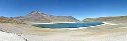
Miñiques is the name of a lake and a volcano in Chile. It lies south of Laguna Miscanti and at the foot of the Cerro Miscanti volcano. The lake is fed from Laguna Miscanti by seepage and its waters are brackish.
Lake
Laguna Miñiques lies at an altitude of 4,120 metres (13,520 ft) and is a lake with a surface area of 1.6 square kilometres (0.62 sq mi).[1] It is a fault-bound lake like Laguna Miscanti and Laguna Lejia farther north, and receives inflow from Laguna Miscanti by seepage;[2] a lava flow separates Laguna Miñiques from Laguna Miscanti.[3] Like Miscanti, the waters of Laguna Miñiques are brackish.[4]
Biology
The cladocerans Alona pulchella and Daphnia, the copepods Boeckella poopoensis and unidentified species of cyclopoida inhabit the lake.[1] The lake is part of the Los Flamencos National Reserve[5] and a tourism destination.[6]
Climate
The regional climate is dry and influenced by the Atacama Desert in that regard, although the summits of the Western Cordillera have higher precipitation amounts, especially towards the north such as at Parinacota. The dry climate restrains the development of glaciers in favour of a terrain that is influenced by periglacial processes.[7] Presently, the average precipitation on Laguna Miñiques is about 180 millimetres per year (7.1 in/year) and the annual temperature averages 2 °C (36 °F).[8]
During the Pleistocene and earliest Holocene however increased precipitation resulted in advances of glaciers[9] and in the growth of lakes.[10] In the case of Miñiques, the lakes Miscanti and Pampa Varela (now a dry lake[11]) farther south became connected; a stream delta at Miñiques goes back to that time.[12]
References
- 1 2 Ríos, Patricio De Los; Gajardo, Gonzalo (1 July 2010). "A Null Model to Explain Zooplankton Species Associations in Saline Lakes of the South American Altiplano (14-27°S)". Crustaceana. 83 (7): 773. doi:10.1163/001121610X498764. ISSN 1568-5403 – via http://repositoriodigital.uct.cl/bitstream/handle/10925/858/NULL_MODEL_RIOS_2010.pdf.
- ↑ Valero-Garcés, Blas L.; Grosjean, Martin; Schwalb, Antje; Geyh, Mebus; Messerli, Bruno; Kelts, Kerry (1 July 1996). "Limnogeology of Laguna Miscanti: evidence for mid to late Holocene moisture changes in the Atacama Altiplano (Northern Chile)". Journal of Paleolimnology. 16 (1): 4. doi:10.1007/BF00173268. ISSN 0921-2728.
- ↑ "Miñiques". Global Volcanism Program. Smithsonian Institution.
- ↑ Grosjean 2001, p. 36.
- ↑ González, Juan; Wolter, Gabriela Lucia Luna; Valenzuela, Mario; Vita, Antonio (December 2007). "Actualización del Plan de Ordenación forestal y de desarrollo participativo para el bosque de Tambillo, Comuna de San Pedro de Atacama, Región de Antofagasta" (PDF). ResearchGate (in Spanish). UNIVERSIDAD DE CHILE FACULTAD DE CIENCIAS FORESTALES. p. 10. Retrieved 26 February 2018.
- ↑ Guijón, Rodrigo; Henríquez, Fernando; Naranjo, José Antonio (1 December 2011). "Geological, Geographical and Legal Considerations for the Conservation of Unique Iron Oxide and Sulphur Flows at El Laco and Lastarria Volcanic Complexes, Central Andes, Northern Chile". Geoheritage. 3 (4): 304. doi:10.1007/s12371-011-0045-x. ISSN 1867-2477.
- ↑ Schröder 1999, p. 119.
- ↑ Risacher, François; Fritz, Bertrand (1 February 2009). "Origin of Salts and Brine Evolution of Bolivian and Chilean Salars". Aquatic Geochemistry. 15 (1–2): 128. doi:10.1007/s10498-008-9056-x. ISSN 1380-6165.
- ↑ Schröder 1999, p. 121.
- ↑ Messerli, Bruno; Grosjean, Martin; Graf, Kurt; Schotterer, Ueli; Schreier, Hans; Vuille, Mathias (1992). "Die Veränderungen von Klima und Umwelt in der Region Atacama (Nordchile) seit der Letzten Kaltzeit". Erdkunde (in German). 46 (3): 265. doi:10.3112/erdkunde.1992.03.09.
- ↑ Grosjean 2001, p. 38.
- ↑ Grosjean 2001, p. 37.
Sources
- Grosjean, M (February 2001). "A 22,000 14C year BP sediment and pollen record of climate change from Laguna Miscanti (23°S), northern Chile". Global and Planetary Change. 28 (1–4): 35–51. doi:10.1016/S0921-8181(00)00063-1. ISSN 0921-8181.
- Schröder, Hilmar (1999). "Vergleichende Periglazialmorphologie im Sommerregengebiet der Atacama". Erdkunde (in German). 53 (2): 119–135. doi:10.3112/erdkunde.1999.02.03.
| Rivers | ||
|---|---|---|
| Lakes | ||
| Wikimedia Commons has media related to Laguna Miñiques. |