Laclede's Landing, St. Louis
|
Laclede's Landing | |
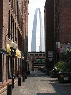 The Gateway Arch viewed from the Landing | |
   | |
| Location | Roughly bounded by Washington, N. 3rd, Dr. Martin Luther King Dr., and the Mississippi River, St. Louis, Missouri |
|---|---|
| Area | 22 acres (8.9 ha) |
| Built | 1780 |
| Architectural style | Late Victorian, Federal |
| NRHP reference # | 76002262[1] |
| Added to NRHP | August 25, 1976 |
Laclede's Landing (/ləˌkliːdz-/), colloquially "the Landing", is a small urban historic district in St. Louis, Missouri, United States. It marks the northern part of the original settlement founded by the Frenchman Pierre Laclède, whose landing on the riverside the placename commemorates.[2] The buildings in the area date from later periods, however.
Located just north of the Gateway Arch National Park (separated by the overland spans of the Eads Bridge) on the Mississippi River front, the Landing is a multi-block collection of cobblestone streets and vintage brick-and-cast-iron warehouses dating from 1850 through 1900, now converted into shops, restaurants, and bars. The district is the only remaining section of St. Louis' 19th-century commercial riverfront.[3]
Transportation
Laclede's Landing has many cobblestone streets. It is adjacent to the Eads Bridge, and Interstate 44 (I-44 does not run over the Eads Bridge). On the Eads Bridge there is the Arch-Laclede's Landing MetroLink Stop. Laclede's Landing once housed Metro's (the local transit agency) headquarters.[4]
In popular culture
Alternative rock band Wilco references the Landing in "Heavy Metal Drummer", a song off the 2002 album Yankee Hotel Foxtrot. Although now based in Chicago, Wilco was initially based in St. Louis and cut their teeth in rock clubs in and around the landing. Frontman Jeff Tweedy grew up in nearby Belleville, Illinois.
References
- ↑ National Park Service (2010-07-09). "National Register Information System". National Register of Historic Places. National Park Service.
- ↑ Conzen, Michael P. "L'héritage morphologique de l'urbanisme français aux États-Unis". Géocarrefour (in French). 77 (2): 161–173. doi:10.3406/geoca.2002.1568.
- ↑ "National Register of Historic Places - Nomination Form" (PDF). Missouri Department of Natural Resources. Retrieved 2008-05-30.
- ↑ http://www.stltoday.com/business/local/metro-to-move-its-hq-to-met-square/article_cba0f3d8-92b3-5a13-8b2d-8e15323c38c4.html
| Wikimedia Commons has media related to Laclede's Landing, St. Louis. |
External links
- http://www.lacledeslanding.com/
- http://www.slfp.com/LacledesLanding.html
- "Laclede's Landing photographs". University of Missouri–St. Louis.
- Laclede's Landing, on a November morning in the late 1970s.
Coordinates: 38°37′49″N 90°11′00″W / 38.63030°N 90.18331°W