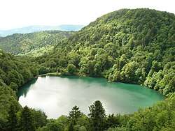
Lac des Perches
| Lac des Perches | |
|---|---|
 | |
| Location | Haut-Rhin |
| Coordinates | 47°50′47″N 6°55′22″E / 47.84639°N 6.92278°ECoordinates: 47°50′47″N 6°55′22″E / 47.84639°N 6.92278°E |
| Type | glacial |
| Basin countries | France |
| Surface area | 0.044 km2 (0.017 sq mi) |
| Max. depth | 17 m (56 ft) |
| Surface elevation | 984 m (3,228 ft) |
Lac des Perches is a lake in Haut-Rhin, France. At an elevation of 984 m, its surface area is 0.044 km². It is located on the Alsatian side of the Vosges Mountains in the municipality of Rimbach-près-Masevaux.
Toponymy
The 19th century German name of the lake was Sternsee (lake of the star). This name came from an alteration of Ternsee ou Ternensee. Its French name comes from a misinterpretation of the patois toponym Lac des Bers (meaning straw), which was read into Bärsch (in German perch) and translated into the present-day name of the lake.[1]
History
It is a Glacial Lake that was dammed in the 16th century to provide power to forges and to textile mills.
References
- ↑ Ober Bers et le lac des Perches, www.randoalsacevosges.com
This article is issued from
Wikipedia.
The text is licensed under Creative Commons - Attribution - Sharealike.
Additional terms may apply for the media files.