Lac d'Aiguebelette
| Lac d'Aiguebelette | |
|---|---|
 | |
 | |
| Location | Savoie |
| Coordinates | 45°33′10″N 5°47′50″E / 45.55278°N 5.79722°ECoordinates: 45°33′10″N 5°47′50″E / 45.55278°N 5.79722°E |
| Primary inflows | Leysse de Novalaise |
| Primary outflows | Tiers |
| Catchment area | 70 km2 (27 sq mi) |
| Basin countries | France |
| Surface area | 5.45 km2 (2.10 sq mi) |
| Max. depth | 71 m (233 ft) |
| Water volume | 166×106 m3 (135,000 acre⋅ft) |
| Surface elevation | 390.5 m (1,281 ft) |
| Frozen | 1909, 1929, 1941, 1942, 1956 |
| Islands | 2 |
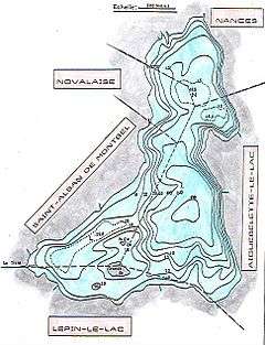
| Settlements | Aiguebelette, Lépin-le-Lac, Saint-Alban-de-Montbel, Novalaise, Nances |
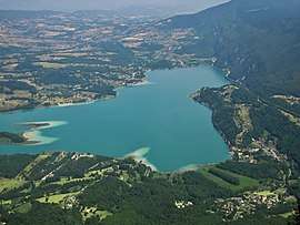
Lac d'Aiguebelette is a natural lake in the commune of Aiguebelette-le-Lac, within the department of Savoie, France.
Description
With a surface area of 5.45 km2 and a depth of 71 meters it is one of the largest natural lakes of France. It is noted for its blue-green colour and the seven hot water springs. The communities of Novalaise, Lépin-le-Lac, Saint-Alban-de-Montbel and Aiguebelette-le-Lac border west side of the lake, whilst the Chaîne de l'Épine ridge lies to the east with its high point at Mont Grêle (1,425 metres (4,675 ft)).
At the southern end there are two islands, La Petite Ile and La Grande Ile which has a chapel.
Recreation
The Chaîne de l'Épine ridge is crossed by hiking trails, and paragliders launch from there during the summer.
Motorboats are not allowed on the lake to preserve the silence and wildlife along the lake. There are noted views of the lake from the church at St. Alban de Montbel and the mountain ridges.
Rowing
The lake hosted the 1997 World Rowing Championships,[1] and also the 2015 competition.[2]
References
External links
| Wikimedia Commons has media related to Lac d'Aiguebelette. |