La Mothe-Achard
| La Mothe-Achard | ||
|---|---|---|
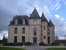 The Chateau of the Domaine de Brandois | ||
| ||
 La Mothe-Achard Location within Pays de la Loire region  La Mothe-Achard | ||
| Coordinates: 46°37′10″N 1°39′28″W / 46.6194°N 1.6578°WCoordinates: 46°37′10″N 1°39′28″W / 46.6194°N 1.6578°W | ||
| Country | France | |
| Region | Pays de la Loire | |
| Department | Vendée | |
| Arrondissement | Les Sables-d'Olonne | |
| Canton | Talmont-Saint-Hilaire | |
| Area1 | 8.73 km2 (3.37 sq mi) | |
| Population (2006)2 | 2,408 | |
| • Density | 280/km2 (710/sq mi) | |
| Time zone | UTC+1 (CET) | |
| • Summer (DST) | UTC+2 (CEST) | |
| INSEE/Postal code | 85152 /85150 | |
| Elevation | 17–61 m (56–200 ft) | |
|
1 French Land Register data, which excludes lakes, ponds, glaciers > 1 km2 (0.386 sq mi or 247 acres) and river estuaries. 2 Population without double counting: residents of multiple communes (e.g., students and military personnel) only counted once. | ||
.svg.png)
La Mothe-Achard is a former commune in the Vendée department in the Pays de la Loire region in western France. On 1 January 2017, it was merged into the new commune Les Achards.[1]
See also
References
- ↑ Arrêté préfectoral 30 September 2016 (in French)
| Wikimedia Commons has media related to La Mothe-Achard. |
| Authority control |
|---|
This article is issued from
Wikipedia.
The text is licensed under Creative Commons - Attribution - Sharealike.
Additional terms may apply for the media files.