La Haye-du-Puits
| La Haye-du-Puits | |
|---|---|
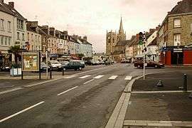 Général-de-Gaulle Place with view of church | |
 La Haye-du-Puits Location within Normandy region  La Haye-du-Puits | |
| Coordinates: 49°17′27″N 1°32′28″W / 49.2908°N 1.5411°WCoordinates: 49°17′27″N 1°32′28″W / 49.2908°N 1.5411°W | |
| Country | France |
| Region | Normandy |
| Department | Manche |
| Arrondissement | Coutances |
| Canton | Créances |
| Intercommunality | Communauté de communes de la Haye-du-Puits |
| Government | |
| • Mayor (2008–2014) | Alain Aubert |
| Area1 | 5.25 km2 (2.03 sq mi) |
| Population (2006)2 | 1,810 |
| • Density | 340/km2 (890/sq mi) |
| Demonym(s) | Haytillons |
| Time zone | UTC+1 (CET) |
| • Summer (DST) | UTC+2 (CEST) |
| INSEE/Postal code | 50236 /50250 |
| Elevation |
29–94 m (95–308 ft) (avg. 37 m or 121 ft) |
|
1 French Land Register data, which excludes lakes, ponds, glaciers > 1 km2 (0.386 sq mi or 247 acres) and river estuaries. 2 Population without double counting: residents of multiple communes (e.g., students and military personnel) only counted once. | |
La Haye-du-Puits is a former commune in the Manche department in Normandy in north-western France. On 1 January 2016, it was merged into the new commune of La Haye.[1]
Heraldry
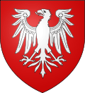 |
The arms of La Haye-du-Puits are blazoned : Gules, an eagle (displayed) argent.
|
See also
References
- ↑ Arrêté préfectoral 20 November 2015 (in French) It is roughly 54 miles from Caen (as the crow flies) and 179 miles from Paris (crow flies)
| Wikimedia Commons has media related to La Haye-du-Puits. |
This article is issued from
Wikipedia.
The text is licensed under Creative Commons - Attribution - Sharealike.
Additional terms may apply for the media files.