La Bréole
| La Bréole | ||
|---|---|---|
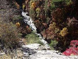 The gorge in La Bréole | ||
| ||
 La Bréole Location within Provence-A.-C.d'A. region  La Bréole | ||
| Coordinates: 44°27′27″N 6°17′43″E / 44.4575°N 6.2953°ECoordinates: 44°27′27″N 6°17′43″E / 44.4575°N 6.2953°E | ||
| Country | France | |
| Region | Provence-Alpes-Côte d'Azur | |
| Department | Alpes-de-Haute-Provence | |
| Arrondissement | Barcelonnette | |
| Canton | Barcelonnette | |
| Area1 | 39.66 km2 (15.31 sq mi) | |
| Population (2008)2 | 346 | |
| • Density | 8.7/km2 (23/sq mi) | |
| Time zone | UTC+1 (CET) | |
| • Summer (DST) | UTC+2 (CEST) | |
| INSEE/Postal code | 04033 /04340 | |
| Elevation |
650–1,590 m (2,130–5,220 ft) (avg. 998 m or 3,274 ft) | |
|
1 French Land Register data, which excludes lakes, ponds, glaciers > 1 km2 (0.386 sq mi or 247 acres) and river estuaries. 2 Population without double counting: residents of multiple communes (e.g., students and military personnel) only counted once. | ||

La Bréole is a former commune in the Alpes-de-Haute-Provence department in southeastern France. On 1 January 2017, it was merged into the new commune Ubaye-Serre-Ponçon.[1]
Population
| Historical population | ||
|---|---|---|
| Year | Pop. | ±% |
| 1765 | 1,082 | — |
| 1793 | 1,078 | −0.4% |
| 1800 | 1,104 | +2.4% |
| 1806 | 1,085 | −1.7% |
| 1821 | 966 | −11.0% |
| 1831 | 932 | −3.5% |
| 1836 | 1,044 | +12.0% |
| 1841 | 1,050 | +0.6% |
| 1846 | 1,082 | +3.0% |
| 1851 | 1,040 | −3.9% |
| 1856 | 976 | −6.2% |
| 1861 | 989 | +1.3% |
| 1866 | 952 | −3.7% |
| 1872 | 881 | −7.5% |
| 1876 | 853 | −3.2% |
| 1881 | 844 | −1.1% |
| 1886 | 876 | +3.8% |
| 1891 | 822 | −6.2% |
| 1896 | 743 | −9.6% |
| 1901 | 726 | −2.3% |
| 1906 | 703 | −3.2% |
| 1911 | 686 | −2.4% |
| 1921 | 612 | −10.8% |
| 1926 | 535 | −12.6% |
| 1931 | 515 | −3.7% |
| 1936 | 477 | −7.4% |
| 1946 | 387 | −18.9% |
| 1954 | 348 | −10.1% |
| 1962 | 477 | +37.1% |
| 1968 | 256 | −46.3% |
| 1975 | 235 | −8.2% |
| 1982 | 252 | +7.2% |
| 1990 | 279 | +10.7% |
| 1999 | 325 | +16.5% |
| 2008 | 346 | +6.5% |
See also
References
- ↑ Arrêté préfectoral 16 December 2016 (in French)
| Wikimedia Commons has media related to La Bréole. |
This article is issued from
Wikipedia.
The text is licensed under Creative Commons - Attribution - Sharealike.
Additional terms may apply for the media files.