LAGEOS
 LAGEOS-1 (diameter=60 cm) | |
| Mission type | Geodesy |
|---|---|
| COSPAR ID | 1976-039A |
| SATCAT no. | 8820 |
| Website | ilrs.cddis.eosdis.nasa.gov |
| Spacecraft properties | |
| Spacecraft type | GEOS |
| Manufacturer | NASA |
| Launch mass | 406.965 kilograms (897.20 lb) |
| Dimensions | 0.60 metres (2 ft 0 in) diameter sphere |
| Start of mission | |
| Launch date | 4 May 1976, 08:00 UTC[1] |
| Rocket | Delta 2913 / Star-24 |
| Launch site | Vandenberg SLC-2W |
| Contractor | NASA |
| Orbital parameters | |
| Reference system | Geocentric |
| Regime | Medium Earth |
| Semi-major axis | 12,271.15 kilometers (7,624.94 mi) |
| Eccentricity | 0.0044560 |
| Perigee | 5,838.33 kilometers (3,627.77 mi) |
| Apogee | 5,947.69 kilometers (3,695.72 mi) |
| Inclination | 109.83 degrees |
| Period | 225.70 minutes |
| Epoch | 5 May 2017, 07:05:23 UTC[2] |
| Instruments | |
| |
| Mission type | Geodesy |
|---|---|
| Operator | NASA |
| COSPAR ID | 1992-070B |
| SATCAT no. | 22195 |
| Website | ilrs.cddis.eosdis.nasa.gov |
| Spacecraft properties | |
| Spacecraft type | LAGEOS |
| Manufacturer | Aeritalia for the Italian Space Agency (ASI) |
| Launch mass | 405.38 kilograms (893.7 lb) |
| Dimensions | 0.60 metres (2 ft 0 in) diameter sphere |
| Start of mission | |
| Launch date | 22 October 1992, 17:09 UTC[1] |
| Rocket | Space Shuttle STS-52 / Italian Research Interim Stage (IRIS) |
| Launch site | Kennedy LC-39B |
| Orbital parameters | |
| Reference system | Geocentric |
| Regime | Medium Earth |
| Semi-major axis | 12,161.84 kilometers (7,557.02 mi) |
| Eccentricity | 0.0137298 |
| Perigee | 5,616.73 kilometers (3,490.07 mi) |
| Apogee | 5,950.68 kilometers (3,697.58 mi) |
| Inclination | 52.65 degrees |
| Period | 222.46 minutes |
| Epoch | 5 May 2017, 07:48:20 UTC[2] |
| Instruments | |
| |
LAGEOS, Laser Geodynamics Satellite or Laser Geometric Environmental Observation Survey, are a series of two scientific research satellites designed to provide an orbiting laser ranging benchmark for geodynamical studies of the Earth. Each satellite is a high-density passive laser reflector in a very stable medium Earth orbit (MEO).
Function and operation
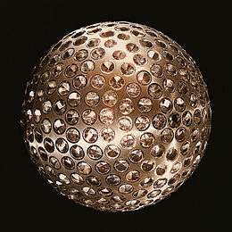
The spacecraft are aluminum-covered brass spheres with diameters of 60 cm (23.62 in) and masses of 400 (881.849 lbs) and 411 kg, covered with 426 cube-corner retroreflectors, giving them the appearance of giant golf balls.[3][4][5] 422 of the retroreflectors are made from fused silica glass while the remaining 4 are made from germanium to obtain measurements in the infrared for experimental studies of reflectivity and satellite orientation.[6] They have no on-board sensors or electronics, and are not altitude-controlled.
They orbit at an altitude of 5,900 kilometres (3,700 mi),[7] well above low earth orbit and well below geostationary orbit, at orbital inclinations of 109.8 and 52.6 degrees.
Measurements are made by transmitting pulsed laser beams from Earth ground stations to the satellites. The laser beams then return to Earth after hitting the reflecting surfaces; the travel times are precisely measured, permitting ground stations in different parts of the Earth to measure their separations to better than one inch in thousands of miles.
The LAGEOS satellites make it possible to determine positions of points on the Earth with extremely high accuracy due to the stability of their orbits. The high mass-to-area ratio and the precise, stable (attitude-independent) geometry of the LAGEOS spacecraft, together with their extremely regular orbits, make these satellites the most precise position references available.
Mission goals
The LAGEOS mission consists of the following key goals:
- Provide an accurate measurement of the satellite's position with respect to Earth.
- Determine the planet's shape (geoid).
- Determine tectonic plate movements associated with continental drift.
Ground tracking stations located in many countries (including the US, Mexico, France, Germany, Poland, Australia, Egypt, China, Peru, Italy, and Japan) have ranged to the satellites and data from these stations are available worldwide to investigators studying crustal dynamics.
There are two LAGEOS spacecraft, LAGEOS-1 launched in 1976, and LAGEOS-2 launched in 1992. As of May 2011, both LAGEOS spacecraft are routinely tracked by the ILRS network.[8]
Time capsule
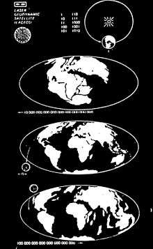
LAGEOS-1 (which is predicted to re-enter the atmosphere in 8.4 million years[6]) also contains a plaque designed by Carl Sagan to indicate to future humanity when LAGEOS-1 was launched. The plaque includes the numbers 1 to 10 in binary. In the upper right is the earth with an arrow pointing to the right, indicating the future. It shows a #1 indicating 1 revolution, equaling 1 year. It then shows 268435456 (in binary; 228) years in the past, indicated by a left arrow and the arrangement of the Earth's continents at that time. The present is indicated with a 0 and both forward and backward arrows. Then the estimated arrangement of the continents in 8.4 million years with a right facing arrow and 8388608 in binary (223). LAGEOS itself is shown at launch on the 0 year, and falling to the Earth in the 8.4 million year diagram.[9][10]
Launch data
See also
- GEOS-3
- PAGEOS
- Geodesy
- Post-glacial rebound
- List of laser articles
- List of laser ranging satellites
- LARES (satellite) a similar object made of mostly tungsten
Further reading
- Sagan, Carl (1978). Murmurs of Earth: The Voyager Interstellar Record. Random House. pp. 8–9.
- The Conversation (May 3, 2017) Space bling: ‘jewelled’ LAGEOS satellites help us to measure the Earth,
References
- 1 2 McDowell, Jonathan. "Launch Log". Jonathan's Space Page. Retrieved 6 May 2017.
- 1 2 "Celestrak NORAD Two-Line Element Sets". 5 May 2017. Retrieved 6 May 2017.
- ↑ "Missions - LAGEOS 1&2 - NASA Science". Science.nasa.gov. 1976-05-04. Retrieved 2016-02-22.
- ↑ Kramer, Herbert J. (2013) Observation of the Earth and its Environment: Survey of Missions and Sensors Springer ISBN 9783662090381 p149
- ↑ LAGEOS Characteristics NASA Historical Data Book Volume III Table 4-166 SP-4012
- 1 2 "International Laser Ranging Service". Ilrs.gsfc.nasa.gov. Retrieved 2016-02-22.
- ↑ "JPL Mission and Spacecraft Library, Lageos". space.jpl.nasa.gov. Retrieved March 31, 2011.
- ↑ "International Laser Ranging Service". Ilrs.gsfc.nasa.gov. 2012-09-17. Retrieved 2016-02-22.
- ↑ NASA Press Kit for Project Lageos (1976) p14
- ↑ Magazine, Popular Science (1976-07-01). Science Newsfront - Message for the future. Bonnier Corporation.
External links
| Wikimedia Commons has media related to LAGEOS. |