L'Esperance Rock
 The rock from northeast | |
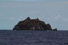
 L'Esperance Rock in the south of the Kermadec Islands | |
| Geography | |
|---|---|
| Coordinates | 31°26′S 178°54′W / 31.433°S 178.900°W |
| Archipelago | Kermadec Islands |
| Area | 4.8 ha (12 acres) |
| Highest elevation | 70 m (230 ft) |
| Administration | |
| Demographics | |
| Population | 0 |
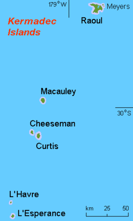
L'Esperance Rock, formerly French Rock, and previously Brind Rock[1](Named after William Brind), is the southernmost islet in the Kermadec Islands, to the north of New Zealand. It is 80 km (50 mi) south of Curtis Island and 600 km (370 mi) northeast of East Cape on New Zealand's North Island at 31°26′S 178°54′W / 31.433°S 178.900°W. The smaller L'Havre Rock lies 8 km (5 mi) to the north-west of L'Esperance; it is a reef that barely reaches the surface. L'Esperance Rock is 250 m (820 ft) in diameter with an area of 4.8 ha (12 acres). It rises to a height of 70 m (230 ft).
Important Bird Area
The island forms part of the Kermadec Islands Important Bird Area, identified as such by BirdLife International because it is an important site for nesting seabirds.[2] It is the site of a substantial breeding colony of grey noddies. Masked boobies have also been recorded breeding there.[3]
See also
References
- ↑ Taonga, New Zealand Ministry for Culture and Heritage Te Manatu. "Brind, William Darby". www.teara.govt.nz.
- ↑ BirdLife International. (2012). Important Bird Areas factsheet: Kermadec Islands. Downloaded from http://www.birdlife.org on 2012-02-03.
- ↑ Greene et al. (2004).
- Greene, T.C.; Scofield, R.P.; Dilks, P.J. (July 2004). Status of Kermadec red-crowned parakeets and the likely effects of a proposed kiore eradication programme. Macauley Island expedition July 2002 (PDF). DOC Science Internal Series 179. Wellington: Department of Conservation, New Zealand. ISBN 0-478-22579-2.
External links