Kysucké Nové Mesto
| Kysucké Nové Mesto | |
| Town | |
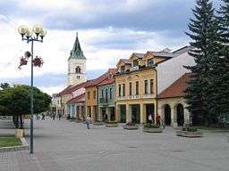 Centre of the city, the Námestie Slobody ("Freedom Square") | |
| Country | Slovakia |
|---|---|
| Region | Žilina |
| District | Kysucké Nové Mesto |
| Tourism region | Severné Považie |
| River | Kysuca |
| Elevation | 358 m (1,175 ft) |
| Coordinates | 49°17′54″N 18°47′12″E / 49.29833°N 18.78667°ECoordinates: 49°17′54″N 18°47′12″E / 49.29833°N 18.78667°E |
| Area | 26.414 km2 (10.199 sq mi) |
| Population | 16,470 (2005-12-31) |
| Density | 624/km2 (1,616/sq mi) |
| First mentioned | 1246 |
| Mayor | Ján Hartel |
| Timezone | CET (UTC+1) |
| - summer (DST) | CEST (UTC+2) |
| Postal code | 024 01 |
| Phone prefix | 421-41 |
| Car plate | KM |
  Location of Kysucké Nové Mesto in Slovakia | |
  Location of Kysucké Nové Mesto in the Žilina Region | |
| Wikimedia Commons: Kysucké Nové Mesto | |
| Statistics: MOŠ/MIS | |
| Website: http://www.kysuckenovemesto.sk | |
Kysucké Nové Mesto (German: Kischützneustadt / Oberneustadl; Hungarian: Kiszucaújhely) is a town in Žilina Region, Slovakia, near the city of Žilina.
History
The first signs of settlement
In 1976 under Stránsky vrch, there were lumps of burnt clay and ceramics found, which highlighted the settlement in this area. The archaeologists date the acquired material back to the La Tène Age. These findings are now stored in the Manor-house of Radoľa located near Kysucké Nové Mesto
The first mention of the city
The town is mentioned for the first time in 1254 (under the name Jesesin, in the Bela's IV donation treaty). In 1321 lachasin is mentioned as a place where toll is collected. The privileges of a town with a market law were given the city (under the name Congesberg) in 1325. In 1358 the name of Nova Civitas (Nové Mesto - New Town) is already used. The inhabitants were mainly engaged in agriculture, sheep breeding, trade and handcraft.
The town in the 19th century was falling due to the floods (in 1813, 1821), the fires (1823, 1904), but also due to the large expatriation in the whole region. After the fire in August 1904, only 30 homes remained in the city. The economic development of the city took place after the Second World War.
The Kysucké Nové Mesto developed mainly the engineering industry.
The relationship with Austro-Hungary was expressed by inhabitants during the WWI in the Riot in Kragujevac (June 2, 1918).
In World War II people fought with German occupation forces not only in Slovakia in the Slovak national uprising, but also in European struggles, contributing to the defeat of fascism.
Kysucké Nové Mesto has been making its present form for centuries. The biggest and fastest changes occurred after World War II.
The importance of the town increased after the year 1950, when the Závody presného strojárstva (later ZVL) were created. The company provided work to thousands of people and started significant changes in the town.
New housing estates, schools, offices, shops, sports facilities were created. Kysucké Nové Mesto has a built infrastructure that is currently being improved to meet the needs of its residents and visitors.
Names
- 150 - Asanka - according to the Greek geographer Ptolemy- settlement lying on the amber road
- 1254 - Jesesin
- 1300 - Yesesin
- 1338 - Jachatin - Chateau of the count Mikuláš Zeech - regional judge, but also the name Lethesin appears in the documents. The part of the word 'Jacha' probably represents name Jakub(James the Less - the patron of the town) and 'Tin' means the castle (the Castle of James).
- 1325 - following names:
- Congesbergh
- Kongesberg
- Königsberg - the Královský vrch (now the Tábor hill), under which the river Kysuca flows. The name of Königsberg was not used, still it was called with the slavic name Jačatín, because most of its inhabitants formed Slavic ethnicity.
- 1358 - Civitas Nova - Castrum Novum - New Town during Ľudovít Veľký
- 1438 - Nowe Mesto - name Jačatín (Jachatin) did not disappear
- 1507 - Kisucza UJhely (Ujvar)
- 1784 - Horní Nové Mesto
- 1873 - Nové Mesto nad Kysucou
- 1907 - Kisuca Ujhely - at the time of Magyarization
- 1920 - Kysucké Nové Mesto
Geography
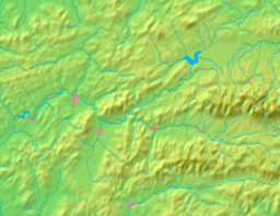
Kysucké Nové Mesto lies at an altitude of 358 metres (1,175 ft) above sea level and covers an area of 26.414 square kilometres (10.199 sq mi).[1] It is located in the Kysuca river valley, between the Javorníky and Kysucká vrchovina mountains, about 10 km (6.21 mi) north of Žilina.
Demographics
According to the 2001 census, the town had 16,558 inhabitants. 95.13% of inhabitants were Slovaks, 1.02% Czechs and 0.79% Roma and Germans.[1] The religious make-up was 86.20% Roman Catholics, 6.79% people with no religious affiliation and 0.47% Lutherans.[1]
Twin towns — sister cities
Kysucké Nové Mesto is twinned with:

References
- 1 2 3 "Municipal Statistics". Statistical Office of the Slovak republic. Archived from the original on 2008-01-11. Retrieved 2008-01-25.
External links
- Official website (in Slovak)
Municipalities of Kysucké Nové Mesto District | ||
|---|---|---|