Kvås
| Kvås | |
|---|---|
| Village | |
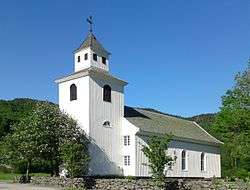 View of the village church | |
 Kvås Location of the village  Kvås Kvås (Norway) | |
| Coordinates: 58°15′42″N 07°11′57″E / 58.26167°N 7.19917°ECoordinates: 58°15′42″N 07°11′57″E / 58.26167°N 7.19917°E | |
| Country | Norway |
| Region | Southern Norway |
| County | Vest-Agder |
| District | Lister |
| Municipality | Lyngdal |
| Elevation[1] | 57 m (187 ft) |
| Time zone | UTC+01:00 (CET) |
| • Summer (DST) | UTC+02:00 (CEST) |
| Post Code | 4588 Kvås |
Kvås is a village in Lyngdal municipality in Vest-Agder county, Norway. The village is located in the Lyngdalen valley, along the river Lygna, about 16 kilometres (9.9 mi) northeast of the municipal centre of Alleen and about 10 kilometres (6.2 mi) west of the village of Konsmo in Audnedal. The Kvås Church lies at the center of the village. Kvås was the administrative centre of the old municipality of Kvås from 1909 until its dissolution in 1963.
Name
The village (originally the parish) is named after the old Kvås farm (Old Norse: Kváss), since that is where the Kvås Church is located. The meaning of the name probably refers to a "valley" or "hollow".[2]
References
- ↑ "Kvås, Lyngdal (Vest-Agder)". yr.no. Retrieved 2016-10-08.
- ↑ Rygh, Oluf (1912). Norske gaardnavne: Lister og Mandals amt (in Norwegian) (9 ed.). Kristiania, Norge: W. C. Fabritius & sønners bogtrikkeri. p. 252.
This article is issued from
Wikipedia.
The text is licensed under Creative Commons - Attribution - Sharealike.
Additional terms may apply for the media files.