Coast Tram (Belgium)
| Coast Tram | |
|---|---|
| Kusttram | |
| De Lijn Vicinal Tramways | |
 Map of the route | |
| Operation | |
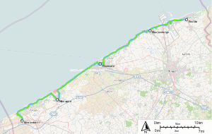
| Locale | Belgian coastal towns from Knokke-Heist to de Panne. |
| Open | 1885 |
| Status | In Service |
| Owner(s) | De Lijn |
| Infrastructure | |
| Track gauge | 1,000 mm (3 ft 3 3⁄8 in) metre gauge |
| Electrification | 600V DC |
| Depot(s) | Adinkerke, De Panne, Nieuwpoortsesteenweg, Oostende, Knokke-Heist |
| Stock | HermeLijn |
| Statistics | |
| Route length | 68 km (42.25 mi) |
| Website | De Kusttram |
| Belgian Coast Tram | |||||||||||||||||||||||||||||||||||||||||||||||||||||||||||||||||||||||||||||||||||||||||||||||||||||||||||||||||||||||||||||||||||||||||||||||||||||||||||||||||||||||||||||||||||||||||||||||||||||||||||||||||||||||||||||||||||||||||||||||||||||||||||||||||||||||||||||||||||||||||||||||||||||||||||||||||||||||||||||||||||||||||||||||||||||||||||||||||||||||||||||||||||||||||||||||||||||||||||||||||||||||||||||||||||||||||||||||||||||||||||||||||||||||||||||||||||||||||||||||||||||
|---|---|---|---|---|---|---|---|---|---|---|---|---|---|---|---|---|---|---|---|---|---|---|---|---|---|---|---|---|---|---|---|---|---|---|---|---|---|---|---|---|---|---|---|---|---|---|---|---|---|---|---|---|---|---|---|---|---|---|---|---|---|---|---|---|---|---|---|---|---|---|---|---|---|---|---|---|---|---|---|---|---|---|---|---|---|---|---|---|---|---|---|---|---|---|---|---|---|---|---|---|---|---|---|---|---|---|---|---|---|---|---|---|---|---|---|---|---|---|---|---|---|---|---|---|---|---|---|---|---|---|---|---|---|---|---|---|---|---|---|---|---|---|---|---|---|---|---|---|---|---|---|---|---|---|---|---|---|---|---|---|---|---|---|---|---|---|---|---|---|---|---|---|---|---|---|---|---|---|---|---|---|---|---|---|---|---|---|---|---|---|---|---|---|---|---|---|---|---|---|---|---|---|---|---|---|---|---|---|---|---|---|---|---|---|---|---|---|---|---|---|---|---|---|---|---|---|---|---|---|---|---|---|---|---|---|---|---|---|---|---|---|---|---|---|---|---|---|---|---|---|---|---|---|---|---|---|---|---|---|---|---|---|---|---|---|---|---|---|---|---|---|---|---|---|---|---|---|---|---|---|---|---|---|---|---|---|---|---|---|---|---|---|---|---|---|---|---|---|---|---|---|---|---|---|---|---|---|---|---|---|---|---|---|---|---|---|---|---|---|---|---|---|---|---|---|---|---|---|---|---|---|---|---|---|---|---|---|---|---|---|---|---|---|---|---|---|---|---|---|---|---|---|---|---|---|---|---|---|---|---|---|---|---|---|---|---|---|---|---|---|---|---|---|---|---|---|---|---|---|---|---|---|---|---|---|---|---|---|---|---|---|---|---|---|---|---|---|---|---|---|---|---|---|---|---|---|---|---|---|---|---|---|---|---|---|---|---|---|---|---|---|---|---|---|---|---|---|---|---|---|---|---|---|---|---|---|---|---|---|---|---|---|---|---|---|---|---|---|---|---|---|---|---|---|---|---|---|---|---|---|---|---|---|---|---|---|---|---|---|---|---|---|---|---|---|---|---|---|---|---|---|---|---|---|---|
| |||||||||||||||||||||||||||||||||||||||||||||||||||||||||||||||||||||||||||||||||||||||||||||||||||||||||||||||||||||||||||||||||||||||||||||||||||||||||||||||||||||||||||||||||||||||||||||||||||||||||||||||||||||||||||||||||||||||||||||||||||||||||||||||||||||||||||||||||||||||||||||||||||||||||||||||||||||||||||||||||||||||||||||||||||||||||||||||||||||||||||||||||||||||||||||||||||||||||||||||||||||||||||||||||||||||||||||||||||||||||||||||||||||||||||||||||||||||||||||||||||||
The Coast Tram (Dutch: Kusttram) is a public transport service connecting the cities and towns along the entire Belgian (West Flanders) coast, between De Panne near the French border and Knokke-Heist. At 68 km (42 miles) in length, it is the longest tram line in the world,[1] as well as one of the few interurban tramways in the world to remain in operation. The line is built at 1,000 mm (3 ft 3 3⁄8 in) metre gauge and fully electrified at 600 V DC.
History
The first section of the line between Oostende and Nieuwpoort was opened in 1885, although the original route was further inland than the modern one and only short sections of the original section in Oostende and Nieuwpoort centres are still in operation. On its creation, the line was managed by the NMVB (Nationale Maatschappij van Buurtspoorwegen), that operated an interurban tram system throughout Belgium. In 1991, the NMVB/SNCV was broken into two regional companies, one Walloon and the other Flemish, with the Flemish successor company, Vlaamse Vervoermaatschappij De Lijn taking responsibility for operation of the coastal tram.
Characteristics
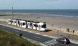
The service makes 69 stops along the 68 km line, with a tram running every 10 min during the peak summer months (every 20 min in the winter months), and it is used by over 3 million passengers. The service has recently been made more accessible by new low-floor centre sections to existing vehicles and a few new HermeLijn low-floor trams.
While most of the older trams are unidirectional and so have to be turned on a loop in order to reverse direction, the newer ones are bidirectional, with driving positions and doors on both end/sides.
An interesting feature is the two alternative routes that exist around both ends of the Leopoldkanaal locks, just east of Zeebrugge, and the similar single track diversion around the inland end of the Boudewijnkanaal lock. That avoids delays when the road bridge that the tram line normally follows is raised for boats passing under it. There is a similar feature at the southern end of Ostend station around the lock entrance to the Vlotdok.
Gallery
 Tram in Oostende Henegouwenstraat stop
 Ostend (tram and rail) station
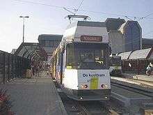 Tram in Oostende station
 Tram in depot of Ostend
 Tram leaving De Haan station
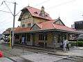 De Haan station
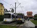 A couple of trams in De Haan station
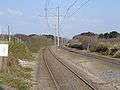 Tracks between De Haan and Wenduine
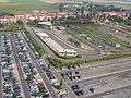 Depot at Adinkerke
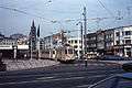 Classic tram in 1980s
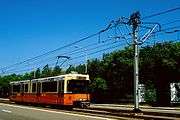 1986
1986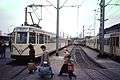 Oostende in 1982
 Also in 1982 Oostende
See also
References
- ↑ "Facts & Figures". Yarra Trams. Retrieved 16 April 2013.
External links
| Wikimedia Commons has media related to Coastal tram, Belgium. |
- (in English) De Kusttram (Official site)
- (in English) De Lijn (Official site)
- (in Dutch) Buurtspoorweg foto archief
- (in Dutch) TRAMANIA Buurtspoorweg sponsoring
- (in English) UrbanRail.net page
| National |
| |
|---|---|---|
| Flanders | ||
| Wallonia |
| |
| Brussels |
| |