Kumusi River
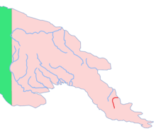
The Kumusi River (also known as the Kamusi River) is a river located in the Oro Province of Papua New Guinea. Known for its width and its strength, the Kumusi has had a significant impact on the history of the Oro Province. It was a significant factor in the Kokoda Track Campaign and also a contributing factor to the destruction caused by Cyclone Guba.
History
World War II
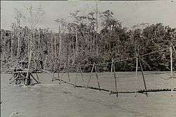

Due to its relative proximity to the Kokoda Track, the Kumusi River was often a factor in the Kokoda Track Campaign of World War II. The fast flowing and wide river provided natural barrier from enemy, and gave the soldiers a distinct advantage.[1] There were few bridges, the solid ones were often bombed to break a supply line.[2] Soldiers often had to walk, or use rafts through the powerful current in order to get across[3] Many fatalities were recorded as the current overwhelmed the soldiers.[3] One of the most notable deaths was that of Japanese Major General Tomitaro Horii. After the Oivi-Gorari battle, the Japanese chaotically crossed the river at Wairopi.[4][5] Although his horse already had drowned, Horii opted to try and cross on a raft. He soon fell into the water and drowned.[5]
Cyclone Guba
On 14 and 15 November 2007, Cyclone Guba hit the Oro Province. The Cyclone brought five days of solid rain, causing widespread flooding; the Kumusi swelled to ten times its original width.[6] The flooding destroyed homes, gardens and in some cases, entire villages were washed away.[7] The flooding completely destroyed the provinces vital infrastructure, over twenty-two bridges were washed away, cutting the link to Popondetta.[8] Of the twenty-two, the Kumusi Bridge,[9] a large steel structure was destroyed, with estimated rebuilding costs at K70 million.[8]
Notes
- ↑ Brune 1992, p. 215
- ↑ Brune 2004, p. 90
- 1 2 Brune 1992, p. 216
- ↑ Brune 2004, p. 419
- 1 2 Lindsay 2002, p. 122
- ↑ "Tasmanian Anglican". Trek Kokoda. Retrieved 22 November 2008.
- ↑ "Building Blocks". The National. Retrieved 22 November 2008.
- 1 2 "Islands Business". Islands Business International. Retrieved 22 November 2008.
- ↑ "Cyclone Guba Devastates Kokoda Area". Kokoda Trekking. Retrieved 22 November 2008.