Kumta
| Kumtaಕುಮುಟ | |
|---|---|
| Town | |
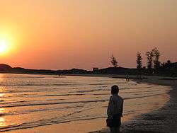 Kumta Sunset at Beach | |
 Kumtaಕುಮುಟ Location in Karnataka, India | |
| Coordinates: 14°25′N 74°24′E / 14.42°N 74.4°ECoordinates: 14°25′N 74°24′E / 14.42°N 74.4°E | |
| Country |
|
| State | Karnataka |
| Region | Coastal Karnataka |
| District | Uttara Kannada |
| Named for | Beauty |
| Government | |
| • Type | [[]] |
| • MLA | Sri Dinakar Keshav Shetty |
| • Assistant Commissioner | Lakshmi Priya K IAS |
| Area | |
| • Total | 15.34 km2 (5.92 sq mi) |
| Area rank | 9th |
| Elevation | 2 m (7 ft) |
| Population (2011) | |
| • Total | 146,177 (As per 2,018 election votes) |
| • Rank | 2nd |
| • Density | 1,957.2/km2 (5,069/sq mi) |
| Languages | |
| • Official | Kannada |
| Time zone | UTC+5:30 (IST) |
| PIN | 581 343 |
| Telephone code | +91-(0)8386 |
| Vehicle registration | KA-47 |
| Lok Sabha Constituency | Uttara Kannada (Lok Sabha constituency) |
| Climate | Monsoon (Köppen) |
| Website |
www |
'Kumta'ಕುಮುಟ is a town and a taluk in the Uttara Kannada district of Karnataka, India.[1] Kumta is about 142 km south of Margao and 58 km north of Bhatkal. It is situated 72.7 km from Karwar, the district headquarters. It is one of the important stations along the Konkan Railway line running between Mumbai and Mangalore.
Geography
The city of Kumta is located on the Arabian sea coast in the district of North Kanara in the state of Karnataka. Kumta is adjacent to the vast western ghats 14°25′N 74°24′E / 14.42°N 74.4°E. It has an average elevation of 3 metres (9 feet).
To the north of city, the major Aghanashini river joins the Arabian Sea on her way rendering stunning scenery. The town of Gokarna near Kumta is famous for beaches. A nearby Rock Climbing spot called Yana is also beautiful with its massive black rock formations and nature trails.
Places around Kumta include:
- Gokarna is just 30 km.
- Kadle Beach
- Gokarna Beaches,
- Yana is just 20 km from Kumta.
- Dhareshwar Beach
- Tuin Beach
- Kumta Beach
- Nirvana beach
- Baada Temple and Beach
- Mirjan Fort
 Mirjan Fort, originally built in the 15th century
Climate
It is located in the sea coast, the town experiences a tropical wet and dry climate. About 85% of rainfall occurs in June to September ie in South West monsoon season. The town receives 350-400cm of rainfall every year.
Transportation
Road
Kumta is very well connected by road. One of the busiest highway National Highway 66 (NH 66-Panvel-Kochi-Kanyakumari) passes through Kumta. Kumta is also connected to State Highway-142 (SH 142 - Kumta-Sirsi) and also to Kumta-Siddapura Road.
The North Western Karnataka Road Transport Corporation (NWKRTC), is the state run bus service in Kumta. It serves routes to towns and cities within the North-Western part of Karnataka and adjoining states of Maharashtra, Goa, Telangana and Andhra Pradesh. Also there are plenty of private busses operating from Kumta.
Rail
Kumta [KT] is well connected through Konkan railways, which has frequent trains plying from Delhi, Mumbai, Ahmedabad, Mangalore, Thiruvananthapuram, Margao, Karwar towards Mangalore (Mangalore Central [MAQ] and Mangalore Junction [MAJN]), Bengaluru, Mysore, Ernakulam and also vice versa. The journey between Margao & Kumta takes not more than 2 hours. The Railway Station is very near to city situated about a kilometer away from National Highway.
Geography
Places adjacent to Kumta | |
|---|---|
References
External links
| Wikimedia Commons has media related to Kumta. |