Kumplampoika
| Kumplampoika Kumbalampoika | |
|---|---|
| village | |
 Kumpalam poika | |
| Coordinates: 9°19′0″N 76°48′0″E / 9.31667°N 76.80000°ECoordinates: 9°19′0″N 76°48′0″E / 9.31667°N 76.80000°E | |
| Country |
|
| State | Kerala |
| District | Pathanamthitta |
| Government | |
| • Type | Panchayath |
| Area | |
| • Total | 10 km2 (4 sq mi) |
| Population (2008) | |
| • Total | 10,000 |
| • Density | 1,000/km2 (2,600/sq mi) |
| Languages | |
| • Official | Malayalam, English |
| Time zone | UTC+5:30 (IST) |
| PIN | 689661 |
| Telephone code | 04735 |
| Vehicle registration | KL-03 |
| Nearest city | Pathanamthitta |
| Sex ratio | 1000m:1000f ♂/♀ |
| Literacy | 99% |
| Lok Sabha constituency | Pathanamthitta |
| Climate | Moderate (Köppen) |
Kumplampoika is a village in Pathanamthitta district of Kerala, India.
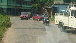
Kumpalampoika Town
Kumplampoika Highschool
History
Kumplampoika evolved out of "Kumbhi Ulavum Poika" which literally connotes the presence of "Kumbhi" (elephant) in the village until a few hundred years back.
Landmarks
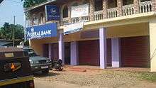
There are three churches, temples, branches of major banks, library (Bodleian library, RegNo. 03 RNI 1797 affiliated by State Library council), co-operative societies, a retail market, and a vegetable market.
Transportation
Kumplampoika is 8 km equidistant from Pathanamthitta and Ranni.
Economy
The main contribution to the economy is in the form of remittance from NRIs and rubber plantations and other low scale farm cultivation.
| Wikimedia Commons has media related to Kumplampoika. |
This article is issued from
Wikipedia.
The text is licensed under Creative Commons - Attribution - Sharealike.
Additional terms may apply for the media files.