Kukisvumchorr
| Kukisvumchorr | |
|---|---|
 | |
| Highest point | |
| Elevation | 1,143 m (3,750 ft) |
| Coordinates | 67°41′44″N 33°43′14″E / 67.69556°N 33.72056°E |
| Geography | |
| Country | Russia |
| State/Province | Murmansk region |
| Parent range | Khibiny Mountains |
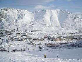
Kukisvumchorr (Russian: Кукисвумчорр) is a mountain part of the Khibiny Mountains mountain range in Russia. It is located near the centre of the range. The summit is bare and stony, while the sides are covered with tundra vegetation. The mountain has an interesting mineralogy, notable for its composition of nepheline syenite.[1] Apatite is mined from the area.[2] The nearby Kukisvumchorr Microdistrict shares the same name as the mountain. An earthquake occurred on 21 October 2010 of magnitude 3.2; mining was suspected as a potential cause.[3]
References

On the plateau of Kukiscumchorr
- ↑ Pekov, Igor V.; Podlesnyi, Alexander S. Kukisvumchorr Deposit: Mineralogy of Alkaline Pegmatites and Hydrothermalites. Ocean Pictures. ISBN 9785900395531.
- ↑ I︠A︡kovenchuk, Viktor. Khibiny. Laplandia Minerals. pp. 215, 277. ISBN 9785900395487.
- ↑ "В Мурманской области произошло странное землетрясение: то ли техногенное, то ли естественное". NEWSru.com (in Russian). Retrieved 3 April 2017.
This article is issued from
Wikipedia.
The text is licensed under Creative Commons - Attribution - Sharealike.
Additional terms may apply for the media files.