Kujang County
| Kujang County 구장군 | |
|---|---|
| County | |
| Korean transcription(s) | |
| • Chosŏn'gŭl | 구장군 |
| • Hanja | 球場郡 |
| • McCune–Reischauer | Kujang-gun |
| • Revised Romanization | Gujang-gun |
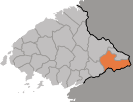 Map of North Pyongan showing the Location of Kujang | |
| Country | North Korea |
| Province | North P'yŏngan |
| Administrative divisions | 1 ŭp, 5 rodongjagu, 22 ri |
| Area | |
| • Total | 584 km2 (225 sq mi) |
| Population (2008)[1] | |
| • Total | 139,337 |
Kujang County is a kun, or county, in southeastern North P'yŏngan province, North Korea. It was created in 1952 from part of Nyŏngbyŏn county, as part of a nationwide reorganization of local government. It borders Nyŏngbyŏn on the west, Hyangsan and Unsan counties on the north, Nyŏngwŏn on the east, and Kaech'ŏn and Tŏkch'ŏn cities to the south.
Geography
The Myohyang Mountains stretch across the eastern part of Kujang. The highest point is Kalbong (칼봉, 1530 m) in the north. The Ch'ŏngch'ŏn River flows through the centre of the county, and the Kuryong River flows along its western flank. Due to the mountainous terrain, only 17% of the county's land is cultivated, while 74% is occupied by forestland.
Administrative divisions
Kujang county is divided into 1 ŭp (town), 5 rodongjagu (workers' districts) and 22 ri (villages):
| Chosŏn'gŭl | Hanja | |
|---|---|---|
| Kujang-ŭp | 구장읍 | 球場邑 |
| Ryongch'ŏl-lodongjagu | 룡철로동자구 | 龍鐵勞動者區 |
| Ryongdŭng-rodongjagu | 룡등로동자구 | 龍登勞動者區 |
| Ryongmul-lodongjagu | 룡문로동자구 | 龍門勞動者區 |
| Ryongsu-rodongjagu | 룡수로동자구 | 龍水勞動者區 |
| Tŭngrip-rodongjagu | 등립로동자구 | 登立勞動者區 |
| Chosal-li | 조산리 | 造山里 |
| Chungch'o-ri | 중초리 | 中草里 |
| Hach'o-ri | 하초리 | 下草里 |
| Hajang-ri | 하장리 | 下長里 |
| Kaehwa-ri | 개화리 | 開華里 |
| Kwisang-ri | 귀상리 | 貴祥里 |
| Muksi-ri | 묵시리 | 墨時里 |
| Ryongyŏl-li | 룡연리 | 龍淵里 |
| Sambong-ri | 삼봉리 | 三峰里 |
| Sangch'o-ri | 상초리 | 上草里 |
| Sang'i-ri | 상이리 | 上耳里 |
| Sanggu-ri | 상구리 | 上九里 |
| Sao-ri | 사오리 | 沙烏里 |
| Sinhŭng-ri | 신흥리 | 新興里 |
| Somil-li | 소민리 | 蘇民里 |
| Song'o-ri | 송호리 | 松湖里 |
| Sugu-ri | 수구리 | 水口里 |
| Taep'ung-ri | 대풍리 | 大豊里 |
| To'gwal-li | 도관리 | 都館里 |
| Unhŭng-ri | 운흥리 | 雲興里 |
| Ullyong-ri | 운룡리 | 雲龍里 |
| Uhyŏl-li | 우현리 | 牛峴里 |
Climate
The average annual temperature is 8.4 °C, with a January mean of -10.4 °C and an August mean of 24.2 °C. The average annual rainfall is 1300 mm, making for a comparatively cool and wet climate.
Economy
Zinc, coal, and mica are mined in the district. Factories produce cement and rail cars.
Transportation
The Manp'o, P'yŏngdŏk and Ch'ŏngnyŏn P'arwŏn lines of the Korean State Railway intersect in Kujang, along with various branch lines serving the county's mines. There is also a road grid.
References
- ↑ DPR Korean Central Bureau of Statistics: 2008 Population Census Archived 2010-03-31 at the Wayback Machine. (Population 2008, published in 2009)
- Bibliography
- International Information Research Institute (국제정보연구소) (1999). "구장군". 北韓情報總覽 2000 [Bukhan jeongbo chong-ram 2000]. Seoul: Author. p. 842.
See also
External links
- (in Korean) In Korean language online encyclopedias:

Coordinates: 39°52′02″N 126°01′41″E / 39.86722°N 126.02806°E