Kruszyniany
| Kruszyniany | |
|---|---|
| Village | |
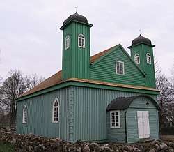 Wooden Kruszyniany Mosque | |
 Kruszyniany | |
| Coordinates: 53°10′50″N 23°48′54″E / 53.18056°N 23.81500°ECoordinates: 53°10′50″N 23°48′54″E / 53.18056°N 23.81500°E | |
| Country |
|
| Voivodeship | Podlaskie |
| County | Sokółka |
| Gmina | Krynki |
| Population | 160 |

Kruszyniany [kruʂɨˈɲanɨ] is a village in the administrative district of Gmina Krynki, within Sokółka County, Podlaskie Voivodeship, in north-eastern Poland, close to the border with Belarus.[1]
The village has a population of 160. In the past, it was primarily a Lipka Tatar settlement. Up until this day, the Tatars still remain as the only minority in the village. The Tatars are Sunni Muslims. Sites of interest in the village include a wooden mosque from the 18th century (one of the two oldest in Poland), a Muslim cemetery and an Eastern Orthodox cemetery with an Orthodox church.
The village was named one of Poland's official national Historic Monuments (Pomnik historii), as designated November 20, 2012. Its listing is maintained by the National Heritage Board of Poland.
References
External links
| Wikimedia Commons has media related to Kruszyniany. |