Kroschel, Minnesota
| Kroschel, Minnesota | |
|---|---|
| Unincorporated community | |
 Kroschel, Minnesota Location of the community of Kroschel within Kanabec County  Kroschel, Minnesota Kroschel, Minnesota (the US) | |
| Coordinates: 46°04′18″N 93°04′34″W / 46.07167°N 93.07611°WCoordinates: 46°04′18″N 93°04′34″W / 46.07167°N 93.07611°W | |
| Country | United States |
| State | Minnesota |
| County | Kanabec |
| Township | Kroschel Township and Pomroy Township |
| Elevation | 1,112 ft (339 m) |
| Time zone | UTC-6 (Central (CST)) |
| • Summer (DST) | UTC-5 (CDT) |
| ZIP code | 55037 |
| Area code(s) | 320 |
| GNIS feature ID | 646264[1] |
Kroschel is an unincorporated community in Kanabec County, Minnesota, United States.
The community is located at the junction of Kanabec County Road 5 (330th Avenue) and Kanabec County Road 20 (Velvet Street).
Kroschel is located within Kroschel Township and Pomroy Township. The South Fork of the Grindstone River flows through the community.
Nearby places include Hinckley, Brook Park, Sandstone, Friesland, Quamba, and Mora.
ZIP codes 55037 (Hinckley) and 55007 (Brook Park) meet near Kroschel. The boundary line between Kanabec and Pine counties is near Kroschel.
References
Municipalities and communities of Kanabec County, Minnesota, United States | ||
|---|---|---|
| Cities | 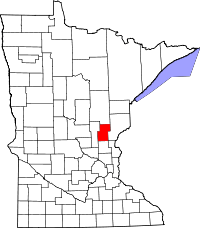 | |
| Townships | ||
| Unincorporated communities | ||
| Indian reservation | ||
| Footnotes | ‡This populated place also has portions in an adjacent county or counties | |
This article is issued from
Wikipedia.
The text is licensed under Creative Commons - Attribution - Sharealike.
Additional terms may apply for the media files.