Kronberg (mountain)
| Kronberg | |
|---|---|
 View from the summit | |
| Highest point | |
| Elevation | 1,663 m (5,456 ft) |
| Prominence | 351 m (1,152 ft) [1] |
| Isolation | 3.2 kilometres (2.0 mi) |
| Parent peak | Säntis |
| Coordinates | 47°17′29″N 9°19′46″E / 47.29139°N 9.32944°ECoordinates: 47°17′29″N 9°19′46″E / 47.29139°N 9.32944°E |
| Geography | |
 Kronberg Location in Switzerland | |
| Location | Appenzell Innerrhoden, Switzerland |
| Parent range | Appenzell Alps |
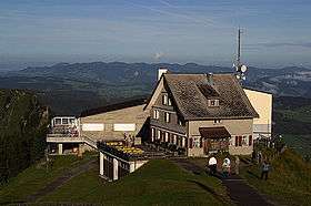
The Kronberg is a mountain of the Appenzell Alps, located west of Appenzell in the Swiss canton of Appenzell Innerrhoden. Its 1,663 metre high summit can be accessed by cable car.

Kronberg cable car
See also
References
External links

- Kronberg Luftseilbahn
- Kronberg on Hikr
- Spherical panorama of Kronberg
This article is issued from
Wikipedia.
The text is licensed under Creative Commons - Attribution - Sharealike.
Additional terms may apply for the media files.