Kriva River (Pčinja)
| Kriva River | |
|---|---|
 Kriva River watershed | |
| Native name | Крива Река, Kriva Reka |
| Country | Republic of Macedonia |
| Physical characteristics | |
| Main source | Carev vrh, Osogovo mountain |
| River mouth |
Pčinja 42°7′14″N 21°50′34″E / 42.12056°N 21.84278°ECoordinates: 42°7′14″N 21°50′34″E / 42.12056°N 21.84278°E |
| Length | 75 km (47 mi) |
| Discharge |
|
| Basin features | |
| Progression | Pčinja→ Vardar→ Aegean Sea |
| Basin size | 1,002 km2 (387 sq mi) |
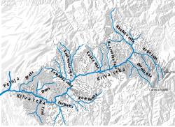
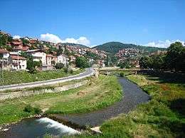
The Kriva River (Macedonian: Крива Река, Kriva Reka) is a 75 km long river in northeastern Macedonia, and the biggest left tributary of the Pčinja River.
The name Kriva Reka means "Curved River" in Macedonian.
Geography and Tributaries
The river rises at the northeastern slopes of Osogovo Mountain below the peak Carev vrh (2,085 m), at an altitude of 1,932 m. On the mouth close to village Klečevce river flows at an altitude of 294 m. From the spring to the first tributary of the Kiselička reka (about 18 km from the source), the river flows northwest, then turns sharply to the southwest.
The major tributaries of the Kriva Reka, are: Kiselicka reka, Gaberska reka, Raska reka, Rankovecka reka, Vetunicka reka, Drzava (or Rudjinska drzava), Zivusa, Duracka reka, Kratovska reka, Povisnica and Vrlej. It belongs to the Aegean sea drainage basin.
Kriva reka drains an area of around 1,002 km²
Bibliography
- Kvalitet na površinskite vodi vo slivot na Kriva reka, O. Dimitrovska, I.Milevski, Bilten za fizička geografija, Skopje, 2005.