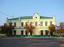
Krasnopillia
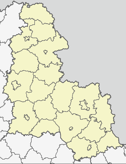
Krasnopillia is an urban-type settlement in Sumy Oblast (province), located in the historic region of the Sloboda Ukraine. It is an administrative seat of Krasnopillia Raion and is only 42 km (26 mi) away from Sumy, the regional center. Population: 8,259 (2015 est.)[1]
Location
The town is located near the Syrovatka River which is a left tributary of the Psel River. Krasnopillia is situated in a close proximity to the Russia-Ukraine border.
History
The town appeared in 1640 as a fort of the Belgorod Defense Line which Muscovy erected in Sloboda Ukraine officially to secure Muscovite southern borders from raids of Crimean Tatars and Nogais. Eventually the town developed into a district center of the Sumy Regiment which also served as a regional subdivision of the Sloboda Ukraine. After disbanding the regimental administrative division in 1765, Krasnopillya became a sloboda and a seat of volost (a county subdivision).
In 1901 in Krasnopillya was built a railway station. The town suffered from the Soviet Holodomor in Ukraine. During the World War II, the Soviet troops left the town to the advancing German forces on October 15, 1941.
References
- ↑ "Чисельність наявного населення України (Actual population of Ukraine)" (PDF) (in Ukrainian). State Statistics Service of Ukraine. Retrieved 1 July 2016.
External links
- Krasnopillya town news portal.
- Krasnopillya at gallerua.com
- Krasnopillya at the Ukrainian Soviet Encyclopedia
| Raions | |||||
|---|---|---|---|---|---|
| Cities |
| ||||
| |||||
Coordinates: 50°46′24″N 35°16′18″E / 50.7732°N 35.2717°E