Krasnokamianka (village)
Coordinates: 44°55′25″N 35°04′32″E / 44.923556°N 35.07544°E
| Krasnokamianka Краснокам'янка Краснокаменка | |
|---|---|
.svg.png) Krasnokamianka Location of Krasnokamianka within Crimea | |
| Coordinates: 44°55′24.8″N 35°4′31.58″E / 44.923556°N 35.0754389°E | |
| Country |
Disputed |
| Republic | Crimea |
| Region | Feodosia municipality |
| Elevation | 430 m (1,410 ft) |
| Population (2014) | |
| • Total | 1,150 |
| Time zone | UTC+4 (MSK) |
| Postal code | 98187 |
| Former names | Kiziltash, Kyzyltash |
Krasnokamianka (Ukrainian: Краснокам'янка; Russian: Краснока́менка; Crimean Tatar: Qızıltaş; all meaning "Red Stone Place"), also known as Kiziltash or Kyzyltash, is a village located in the Feodosiya municipality of the Autonomous Republic of Crimea, a territory recognized by a majority of countries as part of Ukraine and incorporated by Russia as the Republic of Crimea. Population: 1,150 (2014 Census).[1]
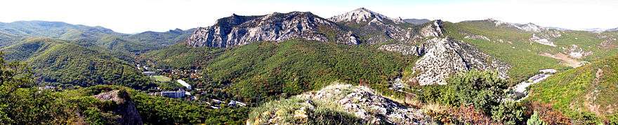
Mountain slopes are forested tracts Kyzyltash pubescent oak, sessile oak and hornbeam ordinary, common relict plants listed in the Red book: high juniper, pistachio tupolistnaya, many species of orchids.
The highest peak in the vicinity Krasnokamianka - Sandyk - Kaya (Stone forehead) - 698 meters above sea level.
In late 1950, the Council of Ministers of USSR adopted a decision on the establishment of central database storage of nuclear weapons - TSBH, i.e. organizations that carry out the assembly and storage of produced in the factories of the Ministry of Medium Machine Building of USSR (USSR Minsredmash, MSM USSR) nuclear weapons.
The first central database storage (object "C ") were in the south of the Crimean military unit (B / W) № 62047 (Krasnokamyanka, Simferopol-10 or Theodosius-13) "Object 712" - Commander of the M. Nemirovsky.
In post-Soviet Ukraine the 47 th regiment of special purpose Crimean territorial command of Interior Troops of Ukraine "Tiger" (a / h 4125), based in Krasnokamenka.
| Cities | ||
|---|---|---|
| Urban-type settlements |
| |
| Villages |
| |
References
- ↑ Russian Federal State Statistics Service (2014). "Таблица 1.3. Численность населения Крымского федерального округа, городских округов, муниципальных районов, городских и сельских поселений" [Table 1.3. Population of Crimean Federal District, Its Urban Okrugs, Municipal Districts, Urban and Rural Settlements]. Федеральное статистическое наблюдение «Перепись населения в Крымском федеральном округе». ("Population Census in Crimean Federal District" Federal Statistical Examination) (in Russian). Federal State Statistics Service. Retrieved January 4, 2016.