Krakau
| Krakau | ||
|---|---|---|
 | ||
| ||
 Krakau Location within Austria
Location within Murau district
| ||
| Coordinates: 47°10′00″N 14°01′00″E / 47.16667°N 14.01667°ECoordinates: 47°10′00″N 14°01′00″E / 47.16667°N 14.01667°E | ||
| Country | Austria | |
| State | Styria | |
| District | Murau | |
| Government | ||
| • Mayor | Gerhard Stolz (ÖVP) | |
| Area | ||
| • Total | 123.6 km2 (47.7 sq mi) | |
| Elevation | 1,173 m (3,848 ft) | |
| Population (1 January 2016)[1] | ||
| • Total | 1,443 | |
| • Density | 12/km2 (30/sq mi) | |
| Time zone | UTC+1 (CET) | |
| • Summer (DST) | UTC+2 (CEST) | |
| Postal code | 8854 | |
| Area codes | +43 3535 | |
| Vehicle registration | MU | |
| Website | www.krakau.at | |

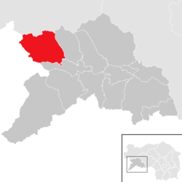
Krakau is a municipality in the district of Murau in Styria, Austria. It was created on 1 January 2015 when the municipalities of Krakaudorf, Krakauhintermühlen and Krakauschatten were merged.[2]
Geography
Krakau lies on a high plateau in the south of the Schladming Tauern.
References
This article is issued from
Wikipedia.
The text is licensed under Creative Commons - Attribution - Sharealike.
Additional terms may apply for the media files.