Kozhuvanal
| Kozhuvanal | |
|---|---|
| town/village | |
 Village Map | |
| Coordinates: 9°39′18″N 76°39′51″E / 9.655014°N 76.664207°ECoordinates: 9°39′18″N 76°39′51″E / 9.655014°N 76.664207°E | |
| Country |
|
| State | Kerala |
| District | Kottayam |
| Government | |
| • Body | Gram Panchayat |
| • President | Kochuthresia Abraham |
| Area | |
| • Total | 21.012 km2 (8.113 sq mi) |
| Population (2001) | |
| • Total | 12,550 |
| • Density | 600/km2 (1,500/sq mi) |
| Languages | |
| • Official | Malayalam, English |
| Time zone | UTC+5:30 (IST) |
| PIN | 686523 |
| Telephone code | 04822 |
| Vehicle registration | KL-35 |
| Nearest city | Pala |
| Sex ratio | 1060 ♂/♀ |
| Literacy | 99%% |
| Lok Sabha constituency | Kottayam |
| Vidhan Sabha constituency | Pala |
| Civic agency | Gram Panchayat |
| Climate | monsoon rains from June - November and summer from December to May (Köppen) |
| Website |
www |
Kozhuvanal is a town in Meenachil, in the district of Kottayam, state of Kerala, India.
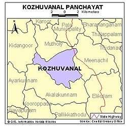
Location
Kozhuvanal is surrounded by Akalakunnam panchayath in south and west, Meenachil in east, Mutholy and Kidangoor in north. It has amenities including schools, post offices, hospital, churchs, temples and stationary shops. State Bank Of Travancore, South Indian Bank, Cooperative Bank, Muthoot Financial Corporation and Kosamattam Financiers have branches in Kozhuvanal.[1]
Panchayath
Kozhuvanal Panchayat has received many awards including the Nirmal Award. It is the first Panchayat in the state to be completely electrified and irrigated. The Panchayat office and the town centre are situated here.
Transportation
Kozhuvanal is connected by road to all neighbouring village centres and to the nearest town Pala. Towns like Kottayam, Kanjirappally, Ponkunnam and Changanacherry are easily accessible from this place by several local roads and highways.The Cherpunkal-Kozhuvanal Road is famous because of the traffic and of the Tourist buses.