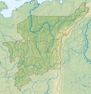
Kozhim River
| Kozhim River | |
| Russian: Ко́жим | |
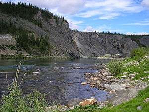 The Kozhim River in Yugyd Va National Park | |
| Country | Russia |
|---|---|
| State | Komi Republic |
| Source | Ural Mountains |
| - coordinates | 64°55′48″N 60°40′07″E / 64.93000°N 60.66861°E |
| Mouth | |
| - coordinates | 65°47′35″N 59°18′10″E / 65.79306°N 59.30278°ECoordinates: 65°47′35″N 59°18′10″E / 65.79306°N 59.30278°E |
| Length | 202 km (126 mi) |
 Russia Komi Republic | |
The Kozhim River is a river in Komi Republic, Russia that runs through the subpolar Ural Mountains.[1][2][3][4][5]
See also
References
- ↑ "Paleomagnetism of paleozoic sediments from the Kozhim River section: On the problem of palinspastic reconstructions of the Subpolar Urals and Pai-Khoi". ResearchGate. Retrieved 11 December 2014.
- ↑ "Transactions (Doklady) of the Russian Academy of Sciences". Retrieved 11 December 2014.
- ↑ "Carbonate Platform Systems". pp. 159–160. Retrieved 11 December 2014.
- ↑ "Rivers of Europe". Retrieved 11 December 2014.
- ↑ Sovfoto. "A prospector panning for gold in the kozhim river in the komi region of russia, 1990s". Getty Images. Retrieved 11 December 2014.
External links
- A gold prospecting settlement by the kozhim river in komi, russia, 1990s (image). Diomedia.com.
This article is issued from
Wikipedia.
The text is licensed under Creative Commons - Attribution - Sharealike.
Additional terms may apply for the media files.