Koy Maeng
| Koy Maeng ឃុំគយម៉ែង | |
|---|---|
| Commune and village | |
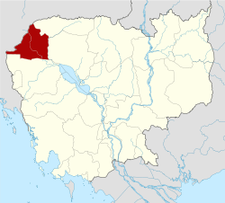
 Koy Maeng Location within Cambodia | |
| Coordinates: 13°11′N 103°15′E / 13.183°N 103.250°ECoordinates: 13°11′N 103°15′E / 13.183°N 103.250°E | |
| Country |
|
| Province | Banteay Meanchey |
| District | Mongkol Borei District |
| Villages | 8 |
| Time zone | UTC+07 |
| Geocode | 010205 |
Koy Maeng is a khum (commune) of Mongkol Borei District in Banteay Meanchey Province in western Cambodia.[1]
Villages
- Koy Maeng
- Sdei Leu
- Phlov Siem
- Ta Nong
- Angkar Khmau
- Kasang Thmei
- Stueng Chas
- Sdei Kraom
References
- ↑ "Banteay Meanchey". cambodia.gov.kh. Archived from the original on December 24, 2008.
This article is issued from
Wikipedia.
The text is licensed under Creative Commons - Attribution - Sharealike.
Additional terms may apply for the media files.