Koropets
| Koropets Коропець | |||
|---|---|---|---|
| Urban-type settlement | |||
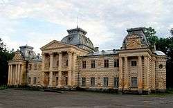 View of the Koropets Palace, built in the beginning of the 19th century. | |||
| |||
 Koropets Location of Koropets in Ukraine | |||
| Coordinates: 48°56′19″N 25°10′46″E / 48.93861°N 25.17944°ECoordinates: 48°56′19″N 25°10′46″E / 48.93861°N 25.17944°E | |||
| Country |
| ||
| Province |
| ||
| District |
| ||
| Founded | 1421 | ||
| Town status | 1984 | ||
| Government | |||
| • Mayor | Hanna Kuilovska | ||
| Area | |||
| • Total | 8.61 km2 (3.32 sq mi) | ||
| Elevation[1] | 201 m (659 ft) | ||
| Population (2017) | |||
| • Total | 3,304[2] | ||
| Time zone | UTC+2 (EET) | ||
| • Summer (DST) | UTC+3 (EEST) | ||
| Postal code | 48370 | ||
| Area code | +380 3555 | ||
| Website | http://rada.gov.ua/ | ||


Koropets (Ukrainian: Коропець; Polish: Koropiec) is an urban-type settlement in the Monastyryska Raion (district) of Ternopil Oblast (province) in western Ukraine. [3] Koropets was first founded in 1421, and it acquired the status of an urban-type settlement in 1984.
The classical palace of Count Stanislav Badeni, built in the beginning of the 19th century, is located in the town of Koropets.[4]
People from Koropets
- Bohdan Hawrylyshyn (1926), economist and an economic advisor to the Ukrainian government.[5]
References
- ↑ "Koropets (Ternopil Oblast, Monastyryska Raion)". weather.in.ua (in Ukrainian). Retrieved 24 January 2012.
- ↑ Чисельність наявного населення України на 1 січня 2017 року. Державна служба статистики України. Київ, 2017. стор.66
- ↑ "Koropets, Ternopil Oblast, Monastyryska Raion". Regions of Ukraine and their Structure (in Ukrainian). Verkhovna Rada of Ukraine. Retrieved 24 January 2012.
- ↑ "Koropets". Castles and Churches of Ukraine (in Ukrainian). Retrieved 25 January 2012.
- ↑ "Bohdan D. Hawrylyshyn". “BOHDAN HAWRYLYSHYN” CHARITABLE FOUNDATION. Retrieved 25 January 2012.
External links
- "Koropets welcomes its guests". Koropets.in.ua (in Ukrainian). Retrieved 25 January 2012.
| Raions | |||||
|---|---|---|---|---|---|
| Cities |
| ||||
| |||||
| Cities | ||
|---|---|---|
| Urban-type settlements | ||
| Villages |
| |
This article is issued from
Wikipedia.
The text is licensed under Creative Commons - Attribution - Sharealike.
Additional terms may apply for the media files.