Kopet Dag
| Kopet Dag | |
|---|---|
| خرِبِت كُپِتدَگ | |
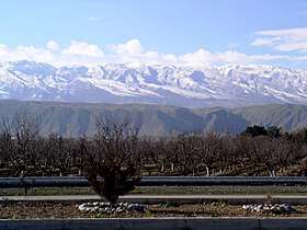 View of the Kopet Dag in early spring from Bereket, Turkmenistan | |
| Highest point | |
| Peak | Kuh-e Quchan |
| Elevation | 3,191 m (10,469 ft) |
| Dimensions | |
| Length | 650 km (400 mi) |
| Naming | |
| Native name | کپهداغ |
| Geography | |
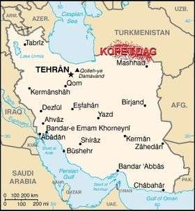 Map of Iran showing the location of Kopet Dag.
| |
| Countries | Iran and Turkmenistan |
| Range coordinates | 38°4′N 57°22.4′E / 38.067°N 57.3733°ECoordinates: 38°4′N 57°22.4′E / 38.067°N 57.3733°E |
The Kopet Dag, Kopet Dagh, or Koppeh Dagh (Persian: کپهداغ; Turkmen: Köpetdag), also known as the Turkmen-Khorasan Mountain Range,[1] is a mountain range on the frontier between Turkmenistan and Iran that extends about 650 kilometres (400 mi) along the border southeast of the Caspian Sea, stretching northwest-southeast from near the Caspian Sea in the northwest to the Harirud River in the southeast.[2] The highest peak of the range in Turkmenistan is the Mount Rizeh (Kuh-e Rizeh), located at the southwest of the capital Ashgabat and stands at 2,940 metres (9,646 ft). The highest Iranian summit is Mount Quchan (Kuh-e Quchan) with 3,191 metres (10,469 ft).[3]
Etymology
The word kopet, or in Persian koppeh, means "pile" or "heap", and the word dag or dagh means "mountain" in Turkic. So Kopet Dagh or Koppeh Dagh could be defined as "the mountain that is piled or heaped" and therefore the words could mean "piled or hilly mountains" or "low hills" in general.
Geology
Geologically, the Kopet Dag Range is made chiefly of Lower Cretaceous sedimentary rocks with a smaller portion of Jurassic rocks in the southeastern parts.[4][5] The mountains were formed in the Miocene and the Pliocene during the Alpine orogeny. As the Tethys Sea was closed and the Arabian Plate collided with the Iranian Plate and was pushed against it and with the clockwise movement of the Eurasian Plate towards the Iranian Plate and their final collision, the Iranian Plate was pressed against the Turan Platform. This collision folded the entire rocks that had been deposited in this geosyncline or basin from the Jurassic to the Miocene and formed the Kopet Dag Mountains.
Topography
The Kopet Dag Range is a region characterized by foothills, dry and sandy slopes, mountain plateaus, and steep ravines. The Kopet Dag is undergoing tectonic transformation, and is subject to severe earthquakes. Earthquakes exceeding seven on the Richter scale have been recorded.[6]
The most western foothills of the Kopetdag mountains are known as the 'Kyurendag Ridge'.
Archaeology
There is archaeological evidence of settlement in the well-watered northern foothills of the Kopet Dag during the Neolithic period. This region is dotted with the multi-period hallmarks characteristic of the ancient Near East, similar to those southwest of the Kopet Dag in the Gorgan Plain in Iran. At Jeitun (or Djeitun), mud brick houses were first occupied c. 6000 BC (see BMAC origins). Also the foothills of the Kopet-Dag near Ashgabat are the site of the remains of the ancient Parthian city of Nisa (Nessa, Nusaý).
Ski resort
This mountain range has a ski resort, officially opened by the former president of Turkmenistan, Saparmurat Niyazov. Despite the lack of snow in the Kopet Dag mountains, Niyazov was determined to build a major resort there.[7][8][9]
Plants and animals

The woodlands of the region are home to many fruit trees, shrubs, and vines that have proved valuable for human use and selective breeding, including pomegranate (Punica granatum), wild grapes Vitis sylvestris, fig (Ficus carica), wild apple (Malus turkmenorum), wild pear (Pyrus boissieriana), wild cherries (Prunus spp., also called Cerasus microcarpa, C. erythrocarpa, C. blinovskii), wild prune (Prunus divaricata), almonds (Amygdalus communis=Prunus dulcis, and A. scoparia=Prunus scoparia), and hawthorns (Crataegus spp.).
See also
References
- ↑ "خرِبِت كُپِتدَگ: Iran". Retrieved 2010-09-09. .
- ↑ Microsoft Encarta World Atlas, 2001, Microsoft Corporation
- ↑ Kopet-Dag Range, Encyclopædia Britannica, www.britannica.com
- ↑ Geological Map of Iran, National Geoscience Database of Iran, www.ngdir.ir
- ↑ Geological Map of the Middle East, published by Geological Survey of Iran, Second Edition, 1993
- ↑ Oct. 5, 1948 - More than 110,000 people were killed by 7.3 quake. Staff (11 January 2005) "World's worst natural disasters since 1900" CBS News
- ↑ Turkmen government announces new construction projects Universal Newswires, accessed on November 15, 2012.
- ↑ We need to talk about Turkmenistan BBC, accessed on February 9, 2017.
- ↑ Ski Turkmenistan! Google Earth Community, accessed on February 9, 2017.