Kongola Constituency
1 = Kongola
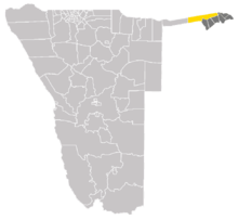
Kongola is the westernmost constituency of Zambezi Region of Namibia, and the largest by area. It is located near the Kwando River. It contains the district village of Kongola and the villages of Chetto, Pipo, Kachenje, Nxtohei, Omega 3, Poca, Mashambo, Mwanzi, Izwi, Mulanga, Munguza, Kahunikwa, Queensland, Kakuwa, and Mitondo.[1] Its population was 7,366 at the Census of Population 2011-08-28.[2]
The area is populated by members of the Mafwe and Mashi tribes, and thus governed by two traditional authorities.[3]
A large area on the western side of the constituency falls under the Bwabwata National Park where approximately 1,900 Khwe San people reside.
Politics
The 2015 regional election was won by David Siyayo Muluti of the SWAPO Party with 1,227 votes, followed by Justings Musupi Kutembeka of the Rally for Democracy and Progress (RDP) with 495 votes.[4]
References
- ↑ Electoral Commission of Namibia: Presidential and National Assembly Elections 2009, Polling Stations. Supplement to several Namibian newspapers, 10 November 2009
- ↑ Statoids: Namibia, Constituencies
- ↑ Sanzila, George (24 October 2012). "Hostel tug-of-war". New Era. Archived from the original on 25 October 2012.
- ↑ "Regional Council Election Results 2015". Electoral Commission of Namibia. 3 December 2015. p. 23. Archived from the original on 8 December 2015.
Constituencies in the Zambezi Region of Namibia | ||
|---|---|---|
Coordinates: 17°58′S 23°17′E / 17.967°S 23.283°E