Kongakut River
| Kongakut River | |
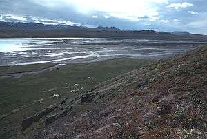 Kongakut River in summer | |
| Country | United States |
|---|---|
| State | Alaska |
| Borough | North Slope |
| Source | |
| - location | Davidson Mountains |
| - elevation | 5,521 ft (1,683 m) [1] |
| - coordinates | 68°48′47″N 143°22′47″W / 68.81306°N 143.37972°W [2] |
| Mouth | Siku Lagoon |
| - location | Beaufort Sea |
| - elevation | 0 ft (0 m) [2] |
| - coordinates | 69°46′35″N 141°42′16″W / 69.77639°N 141.70444°WCoordinates: 69°46′35″N 141°42′16″W / 69.77639°N 141.70444°W [2] |
 Location of the mouth of the Kongakut River in Alaska | |
The Kongakut River flows through parts of North Slope Borough in the U.S. state of Alaska.[2] It begins in the Davidson Mountains of the Brooks Range in the northeastern corner of the state, near the border with Yukon Territory in Canada.[3] The Kongakut flows generally northeast and north through the Arctic National Wildlife Refuge to the Beaufort Sea northwest of Demarcation Point.[3] It was formerly sometimes called the Turner River but that name is now applied to a smaller stream in the vicinity due to confusion as to which was originally meant. The name Kongakut comes from the Inupiaq name for the river, meanining roughly "deer pond".[4]
See also
References
- ↑ Source elevation derived from Google Earth search using GNIS source coordinates.
- 1 2 3 4 "Kongakut River". Geographic Names Information System. United States Geological Survey. January 1, 2000. Retrieved September 2, 2013.
- 1 2 Alaska Atlas & Gazetteer (7th ed.). Yarmouth, Maine: DeLorme. 2010. p. 137. ISBN 978-0-89933-289-5.
- ↑ Orth, Donald (1967) Dictionary of Alaska Place Names Geological Survey professional paper, Volume 567. USGS. Government Printing Office, Washington. pp 539, 994
This article is issued from
Wikipedia.
The text is licensed under Creative Commons - Attribution - Sharealike.
Additional terms may apply for the media files.