Komyshuvakha, Zaporizhia Oblast
| Komyshuvakha Комишуваха | |||
|---|---|---|---|
| Urban-type settlement | |||
| |||
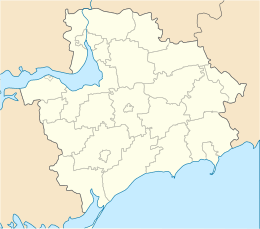 Komyshuvakha Location of Komyshuvakha in Zaporizhia Oblast | |||
| Coordinates: 47°43′10″N 35°31′29″E / 47.71944°N 35.52472°ECoordinates: 47°43′10″N 35°31′29″E / 47.71944°N 35.52472°E | |||
| Country |
| ||
| Province | Zaporizhia Oblast | ||
| District | Orikhiv Raion | ||
| Founded | 1770 | ||
| Town status | 1957 | ||
| Area | |||
| • Total | 6.77 km2 (2.61 sq mi) | ||
| Elevation[1] | 29 m (95 ft) | ||
| Population (2013) | |||
| • Total | 5,374 | ||
| • Density | 790/km2 (2,100/sq mi) | ||
| Time zone | UTC+2 (EET) | ||
| • Summer (DST) | UTC+3 (EEST) | ||
| Postal code | 70530–532 | ||
| Area code | +380 6141 | ||
| Website | http://rada.gov.ua/ | ||

Komyshuvakha (Ukrainian: Комишуваха, Russian: Камышеваха) is an urban-type settlement in the Orikhiv Raion (district) of Zaporizhia Oblast in southern Ukraine. Its population was 5,452 in the 2001 Ukrainian Census.[2] Current population: 5,374 (2013 est.)[3].
Komyshuvakha was first founded in 1770; it was given the status of an urban-type settlement in 1957.[2] It is named after the Komyshuvakha River which flows through the settlement.
References
- ↑ "Komyshuvakha (Zaporizhia Oblast, Orikhiv Raion)". weather.in.ua. Retrieved 8 January 2015.
- 1 2 "Komyshuvakha, Zaporizhia Oblast, Orikhiv Raion". Regions of Ukraine and their Structure (in Ukrainian). Verkhovna Rada of Ukraine. Retrieved 8 January 2015.
- ↑ "Чисельність наявного населення України (Actual population of Ukraine)" (in Ukrainian). State Statistics Service of Ukraine. Retrieved 21 January 2015.
| Cities | ||
|---|---|---|
| Urban-type settlements | ||
| Rural councils |
| |
This article is issued from
Wikipedia.
The text is licensed under Creative Commons - Attribution - Sharealike.
Additional terms may apply for the media files.