Koldok, North Dakota
| Koldok, North Dakota | |
|---|---|
| Unincorporated community | |
 Koldok, North Dakota | |
| Coordinates: 46°55′43″N 97°43′25″W / 46.92861°N 97.72361°WCoordinates: 46°55′43″N 97°43′25″W / 46.92861°N 97.72361°W | |
| Country | United States |
| State | North Dakota |
| County | Barnes |
| Elevation | 1,197 ft (365 m) |
| Time zone | UTC-6 (Central (CST)) |
| • Summer (DST) | UTC-5 (CDT) |
| Area code(s) | 701 |
| GNIS feature ID | 1033772[1] |
Koldok is an unincorporated community in Barnes County, North Dakota, United States. The unincorporated community takes its name from the presence of a large coal storage facility, Coal-dock,[1] having first had to change its name from Brackett due to the latter's similarity with Brocket.
References
Municipalities and communities of Barnes County, North Dakota, United States | ||
|---|---|---|
| Cities | 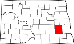 | |
| Townships |
| |
| Unincorporated communities | ||
| Footnotes | ‡This populated place also has portions in an adjacent county or counties | |
This article is issued from
Wikipedia.
The text is licensed under Creative Commons - Attribution - Sharealike.
Additional terms may apply for the media files.