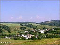
Kolbovce
| Kolbovce | ||
| Village | ||
 | ||
|
||
| Country | Slovakia | |
|---|---|---|
| Region | Prešov | |
| District | Stropkov | |
| Elevation | 210 m (689 ft) | |
| Coordinates | 49°10′N 21°43′E / 49.167°N 21.717°ECoordinates: 49°10′N 21°43′E / 49.167°N 21.717°E | |
| Area | 9.433 km2 (3.64 sq mi) | |
| Population | 176 (2004-12-31) | |
| Density | 19/km2 (49/sq mi) | |
| First mentioned | 1408 | |
| Postal code | 090 31 | |
| Car plate | SP | |
  Location of Kolbovce in Slovakia | ||
_-_background_map.png) _-_outline_map.svg.png) Location of Kolbovce in the Eastern part of the Prešov Region | ||
| Statistics: MOŠ/MIS | ||
Kolbovce is a village and municipality in Stropkov District in the Prešov Region of north-eastern Slovakia.
History
In historical records the village was first mentioned in 1408.
Geography
The municipality lies at an altitude of 210 metres and covers an area of 9.433 km². It has a population of about 182 people.
This article is issued from
Wikipedia.
The text is licensed under Creative Commons - Attribution - Sharealike.
Additional terms may apply for the media files.