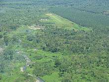
Kokoda Airport
| Kokoda Airport | |
|---|---|
 | |
| Summary | |
| Location | Kokoda, Papua New Guinea |
| Elevation AMSL | 10 ft / 3 m |
| Coordinates | 8°52′59″S 147°44′0″E / 8.88306°S 147.73333°ECoordinates: 8°52′59″S 147°44′0″E / 8.88306°S 147.73333°E |
| Map | |
 KKD Location of airport in Papua New Guinea | |
|
Sources:[1] | |
Kokoda Airport is an airport in Kokoda, Papua New Guinea. The airfield was a focal point of the intense battle along the famous Kokoda trail, during the second World War. It was taken and retaken several times by both Japanese and Australian troops, every time with heavy casualties.
Incidents and accidents
- On 11 August 2009, Airlines PNG Flight 4684, a de Havilland Canada DHC-6 Twin Otter carrying 11 passengers and 2 crew, flying from Port Moresby, crashed into a mountain at Isurava, Papua New Guinea whilst attempting a go around. All passengers and crew perished in the accident.
References
- ↑ World Airport Codes Archived 2009-04-17 at the Wayback Machine.
This article is issued from
Wikipedia.
The text is licensed under Creative Commons - Attribution - Sharealike.
Additional terms may apply for the media files.