Kodza Déré Decauville Railway
| Kodza Déré Decauville Railway | ||||||||||||||||||||||||||||||||||||||||||||||||||||||||||||||||||||||||||||||||||||||||
|---|---|---|---|---|---|---|---|---|---|---|---|---|---|---|---|---|---|---|---|---|---|---|---|---|---|---|---|---|---|---|---|---|---|---|---|---|---|---|---|---|---|---|---|---|---|---|---|---|---|---|---|---|---|---|---|---|---|---|---|---|---|---|---|---|---|---|---|---|---|---|---|---|---|---|---|---|---|---|---|---|---|---|---|---|---|---|---|---|
.png) | ||||||||||||||||||||||||||||||||||||||||||||||||||||||||||||||||||||||||||||||||||||||||
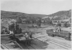
_Pont_construit_par_le_g%C3%A9nie_pour_le_Decauville_sur_le_Kodza-D%C3%A9r%C3%A9.jpg) Crossing a new-built bridge in May 1917 | ||||||||||||||||||||||||||||||||||||||||||||||||||||||||||||||||||||||||||||||||||||||||
| Technical | ||||||||||||||||||||||||||||||||||||||||||||||||||||||||||||||||||||||||||||||||||||||||
| Line length | 13.5 kilometres (8 mi) | |||||||||||||||||||||||||||||||||||||||||||||||||||||||||||||||||||||||||||||||||||||||
| Track gauge | 600 mm (1 ft 11 5⁄8 in) | |||||||||||||||||||||||||||||||||||||||||||||||||||||||||||||||||||||||||||||||||||||||
| ||||||||||||||||||||||||||||||||||||||||||||||||||||||||||||||||||||||||||||||||||||||||
The Kodza Déré Decauville Railway (Greek: Κοτζα Ντερέ ντεκωβίλ) was a 13.5 kilometres (8 mi) long narrow-gauge military railway, which was built and operated by French troops during World War I from 1917 to 1918 at Paionia near Polykastro in Makedonia.
History
.jpg)
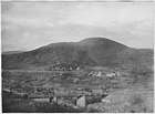
The valley of the Kodza Déré River was of strategical importance to the Allied Forces of World War I because the French headquarters were based near Axioupolis and a camp of the 122th Division and military hospital was located near Pigi. The front line was just a few kilometers above on the height of the Skra-di-Legen Canyon (Σκρα Ντι Λέγκεν), where the Battle of Skra-di-Legen was fought. Similar to the nearby Battles of Doiran in 1917 and 1918 there were lengthy battles with heavy losses in the area.
Route
.jpg)
.jpg)
.jpg)
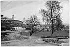
The Decauville railway with a gauge of 600 mm (1 ft 11 5⁄8 in) started from the railway station Axioupolis (Αξιούπολης). The station was known until 1927 as Goumentja. The railway crossed the town of Axioupolis, historically known as Bohemitsa (Μποέμιτσα) passing two churces and a mosque. To gain height quickly, it went through a elaborately built Vróncho Spiral (βρόγχο), to nach Pigi (Πηγή), then known as Isvor. From there it followed the valley of the Kodza Déré River to the terminus Black Tree (μαύρο δένδρο) below the Koúpa Mountain (Κούπα), to supply the Allied Forces at the Macedonian Front with supplies and ammunition. The track and most of the bridges were lifted after the war, but the route with its deep cuts and high embankments is partially still recognisable in the countryside.[1][2]
References
| Wikimedia Commons has media related to Kodza Déré River Railway. |
- ↑ Kostis Manasis (Κώστας Μανασής): Axioupolis - Bohemitsa (Αξιούπολη - Μποέμιτσα)
- ↑ Kodza-Dere (Macédoine). Pont construit par le Génie pour le Decauville. Mai 1917, Tétart. (PDF) p. 28. In: Les Petits Trains de la grande guerre. (HTML) Archives E.C.P.A.D.