Knutstad
| Knutstad | |
|---|---|
| Village | |
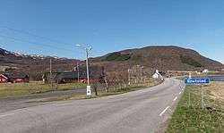 View of the village, with Knutstad Chapel in the distance | |
 Knutstad Location in Nordland  Knutstad Knutstad (Norway) | |
| Coordinates: 68°16′17″N 13°55′41″E / 68.27139°N 13.92806°ECoordinates: 68°16′17″N 13°55′41″E / 68.27139°N 13.92806°E | |
| Country | Norway |
| Region | Northern Norway |
| County | Nordland |
| District | Lofoten |
| Municipality | Vestvågøy |
| Elevation[1] | 14 m (46 ft) |
| Time zone | UTC+01:00 (CET) |
| • Summer (DST) | UTC+02:00 (CEST) |
| Post Code | 8360 Bøstad |
Knutstad is a village in the municipality of Vestvågøy in Nordland county, Norway. The village is located on the northeastern part of the island of Vestvågøya, along the European route E10 highway. Knutstad Chapel is located in the village.
References
- ↑ "Knutstad" (in Norwegian). yr.no. Retrieved 2012-07-06.
This article is issued from
Wikipedia.
The text is licensed under Creative Commons - Attribution - Sharealike.
Additional terms may apply for the media files.