Knoll Open Space
| Knoll Open Space Knoll Park | |
|---|---|
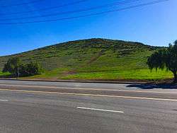 Knoll Open Space as seen from Pepper Tree Playfield. | |
| Type | Open-space park |
| Location | Newbury Park, CA |
| Coordinates | 34°11′26″N 118°57′8″W / 34.19056°N 118.95222°WCoordinates: 34°11′26″N 118°57′8″W / 34.19056°N 118.95222°W |
| Area | 21 acres (8.5 ha) |
| Operated by | Conejo Open Space Conservation Agency (COSCA) |
| Status | Open |
Knoll Open Space, also known as Knoll Park, is a 21 acres (8.5 ha) open-space area in western Newbury Park, California, United States, adjacent to Pepper Tree Playfield.[1][2][3] The Knoll Open Space is owned and operated by the Conejo Open Space Conservation Agency (COSCA), and the flora here includes coastal sage scrub and grass. The 1.9 miles (3.1 km) Knoll Trail (Pepper Tree Vista Trail) goes from its trailhead at North Reino Road and leads to the top of Rabbit Hill (Knoll Hill). The hill offers panoramic views of the Conejo Valley, Santa Monica Mountains, Conejo Mountain, and Boney Mountain.[4]
Sources
- ↑ http://www.conejo-openspace.org/open_space_areas_in_TO.htm#Knoll Archived 2016-02-09 at the Wayback Machine.
- ↑ Sumell, Stephanie (August 2, 2012). "Plan to restripe Reino Road curbed". Thousand Oaks Acorn. Retrieved 21 February 2016.
- ↑ Potkey, Rhiannon (August 3, 2015). "CIF finalist Newbury Park starts with a brand new team'". Ventura County Star. Retrieved 20 February 2016.
- ↑ http://www.conejovalleyguide.com/dosomethingblog/rabbit-hill-knoll-open-space-in-newbury-park.html
This article is issued from
Wikipedia.
The text is licensed under Creative Commons - Attribution - Sharealike.
Additional terms may apply for the media files.