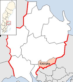
Knivsta Municipality
| Knivsta Municipality Knivsta kommun | ||
|---|---|---|
| Municipality | ||
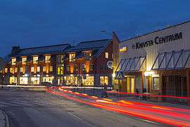 Knivsta by night | ||
| ||
 | ||
| Country | Sweden | |
| County | Uppsala County | |
| Seat | Knivsta | |
| Area[1] | ||
| • Total | 295.12 km2 (113.95 sq mi) | |
| • Land | 282.17 km2 (108.95 sq mi) | |
| • Water | 12.95 km2 (5.00 sq mi) | |
| Area as of 1 January 2014. | ||
| Population (31 December 2017)[2] | ||
| • Total | 18,064 | |
| • Density | 61/km2 (160/sq mi) | |
| Time zone | UTC+1 (CET) | |
| • Summer (DST) | UTC+2 (CEST) | |
| ISO 3166 code | SE | |
| Province | Uppland | |
| Municipal code | 0330 | |
| Website | www.knivsta.se | |

Knivsta Municipality (Knivsta kommun) is a municipality in Uppsala County in east central Sweden. Its seat is located in the town of Knivsta, with some 7,100 inhabitants.
History
Until 1971 Knivsta was a municipality in Stockholm County, when it was merged into Uppsala Municipality and subsequently belonged to Uppsala County. On January 1, 2003 Knivsta was separated from Uppsala to once again form a separate municipality, located in Uppsala County.
The coat of arms symbolises the Stones of Mora where the Swedish Kings were elected in ancient times.
Localities
Elections
These are the election results since the refounding of the municipality from the 2002 election.
Riksdag
| Year | Turnout | Votes | V | S | MP | C | L | KD | M | SD |
|---|---|---|---|---|---|---|---|---|---|---|
| 2002[3] | 82.9 | 7,158 | 5.4 | 31.8 | 5.0 | 6.7 | 17.8 | 10.5 | 20.0 | 1.6 |
| 2006[4] | 85.9 | 7,915 | 3.6 | 24.3 | 5.5 | 10.1 | 9.9 | 8.0 | 34.0 | 2.6 |
| 2010[5] | 88.3 | 8,981 | 3.5 | 19.2 | 7.4 | 9.2 | 9.5 | 7.1 | 38.3 | 4.4 |
| 2014[6] | 89.0 | 9,716 | 3.9 | 21.7 | 8.0 | 8.0 | 6.5 | 6.7 | 30.6 | 10.8 |
Blocs
This lists the relative strength of the socialist and centre-right blocs since 1973, but parties not elected to the Riksdag are inserted as "other", including the Sweden Democrats results from 2002 to 2006. The coalition or government mandate marked in bold formed the government after the election.
| Year | Turnout | Votes | Left | Right | SD | Other | Elected |
|---|---|---|---|---|---|---|---|
| 2002 | 82.9 | 7,158 | 42.2 | 55.0 | 0.0 | 2.8 | 97.2 |
| 2006 | 85.9 | 7,915 | 33.4 | 62.0 | 0.0 | 4.6 | 95.4 |
| 2010 | 88.3 | 8,981 | 30.1 | 64.1 | 4.4 | 1.4 | 98.6 |
| 2014 | 89.0 | 9,716 | 33.6 | 51.8 | 10.8 | 3.8 | 96.2 |
References
- ↑ "Statistiska centralbyrån, Kommunarealer den 1 januari 2014" (Microsoft Excel) (in Swedish). Statistics Sweden. Retrieved 2014-04-18.
- ↑ "Folkmängd i riket, län och kommuner 31 december 2017" (in Swedish). Statistics Sweden. February 21, 2018. Retrieved February 21, 2018.
- ↑ "Valresultat Riksdag Knivsta kommun 2002" (in Swedish). Valmyndigheten. Retrieved 14 September 2017.
- ↑ "Valresultat Riksdag Knivsta kommun 2006" (in Swedish). Valmyndigheten. Retrieved 14 September 2017.
- ↑ "Valresultat Riksdag Knivsta kommun 2010" (in Swedish). Valmyndigheten. Retrieved 14 September 2017.
- ↑ "Valresultat Riksdag Knivsta kommun 2014" (in Swedish). Valmyndigheten. Retrieved 14 September 2017.
External links
- Knivsta Municipality - Official site
- Knivsta map
- Knivstabo.se - A webportal for citizens of Knivsta
Municipalities and seats of Uppsala County | ||
|---|---|---|
| Municipalities | ||
| Municipal seats | ||