Knarrlagsund
| Knarrlagsund Knarrlaget | |
|---|---|
| Village | |
 Knarrlagsund Location of the village  Knarrlagsund Knarrlagsund (Norway) | |
| Coordinates: 63°39′51″N 9°04′49″E / 63.6643°N 09.0803°ECoordinates: 63°39′51″N 9°04′49″E / 63.6643°N 09.0803°E | |
| Country | Norway |
| Region | Central Norway |
| County | Trøndelag |
| District | Fosen |
| Municipality | Hitra |
| Elevation[1] | 14 m (46 ft) |
| Time zone | UTC+01:00 (CET) |
| • Summer (DST) | UTC+02:00 (CEST) |
| Post Code | 7242 Knarrlagsund |
Knarrlagsund or Knarrlaget is a village on the island of Ulvøya in the municipality of Hitra in Trøndelag county, Norway. It is located on the southern part of the island about 2.5 kilometres (1.6 mi) east of the village of Ulvan.
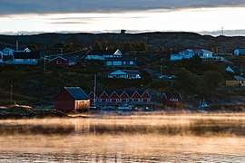
View of the village
The village lies along the Knarrlagsundet strait which separates the islands of Ulvøya and Fjellværsøya. There is a bridge across the strait at Knarrlagsund.
References
- ↑ "Knarrlaget, Hitra (Trøndelag)". yr.no. Retrieved 2018-02-17.
This article is issued from
Wikipedia.
The text is licensed under Creative Commons - Attribution - Sharealike.
Additional terms may apply for the media files.