Kirkop
| Kirkop Ħal Kirkop | |||
|---|---|---|---|
| Local council | |||
 Parish Church of St Leonard | |||
| |||
| Motto(s): Parva non iners | |||
 | |||
| Coordinates: 35°50′31″N 14°29′6″E / 35.84194°N 14.48500°ECoordinates: 35°50′31″N 14°29′6″E / 35.84194°N 14.48500°E | |||
| Country |
| ||
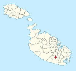
| Region | Southern Region | ||
| District | South Eastern District | ||
| Borders | Luqa, Mqabba, Safi, Żurrieq | ||
| Government | |||
| • Mayor | Terence Agius (PL) | ||
| Area | |||
| • Total | 1.1 km2 (0.4 sq mi) | ||
| Population (March 2014) | |||
| • Total | 2,191 | ||
| • Density | 2,000/km2 (5,200/sq mi) | ||
| Demonym(s) | Koppi (m), Koppija (f), Koppin (pl) | ||
| Time zone | UTC+1 (CET) | ||
| • Summer (DST) | UTC+2 (CEST) | ||
| Postal code | KKP | ||
| Dialing code | 356 | ||
| ISO 3166 code | MT-23 | ||
| Patron saint |
Saint Leonard Saint Joseph | ||
| Day of festa |
3rd Sunday of August 2nd Sunday of July | ||


Kirkop (Maltese: Ħal Kirkop) is a village in the Southern Region of Malta. It is found near the Malta International Airport, and has been inhabited since pre-history. The parish church is dedicated to Saint Leonard. The football team of the village is the Kirkop United Football Club.
History and population
Punic remains of catacombs are found around the village of Kirkop with some of them remain unexplored, and their exploration has been shelved.
In 1969 Anthropologist Jeremy Boissevain published a research on the social fabric of the village in his book Hal Farrug: a village in Malta. Boissevain claims that the people of Ħal Kirkop have lived in the area for centuries because of his assumed comparable bloodline with ancient Phoenician. The Phoenicians occupied the Maltese islands around 700 B.C..
Kirkop has been a village since at least the 11th century.
The name of the village is derived from a family name, or nickname, which owned land in the area. The original name of the village was Casal Prokopju, and is retrieved from the registers of the Maltese militia that existed prior to the rule of the Order of St. John. Through generations, the local population corrupted the original name and was changed to Kirkop.
Kirkop was part of a larger community, as part of the parish of Bir Miftuħ, in the Middle Ages until the Early Modern period. However on May 29, 1592, it was declared a parish on its own right.
The village had a population of 2,260 people in March 2011.[1] By March 2014 this decreased slightly to 2,191 people.[2]
Places, buildings and structures
In Kirkop, one finds the Menhir monolith,[3] which has become the symbol of the village, and a number of Paleo-Christian Catacombs.
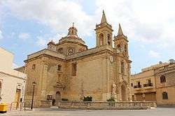
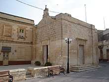
Other notorious buildings and structures are listed monuments which include; the Church of the Annunciation, the Parish Church of St. Leonard, the Chapel St. Nicholas at the cemetery, a cross column (Is-Salib tad-Dejma), and a number of niches scattered around the village.[4]
There are two band clubs, the St. Leonard Band Club and the St. Joseph Band Club, which are used as recreational places by some villagers and visitors.
Kirkop is home to an STMicroelectronics plant, whose production accounts for 60% of national exports.
Kirkop main roads
- Triq Ħal Safi (Safi Road)
- Triq il-Belt Valletta (Valletta Road)
- Triq il-Lewżiet (Almonds Street)
- Triq ir-Ramlija (Sandy Street)
- Triq It-Tielet Waqgha (Third Fall Road)
- Triq l-Industrija (Industry Street)
- Triq San Benedittu (St Benedict Street)
- Triq l-Gharaq tad-Demm (Bloody Sweat Street)
- Triq San Ġwann (St John Street)
- Triq San Nikola (St. Nicholas Street)
- Triq Santu Rokku (St Rocco Street)
- Triq Taż-Żebbiegħ (Taz-Zebbiegh Road)
Band clubs
- St Leonard's Band Club (L-Għaqda Mużikali San Leonardu)
- St Joseph Band Club (L-Għaqda Mużikali San Ġużepp)
Zones in Ħal Kirkop
- Bonu ż-Żgħir
- Il-Għadir (The Lake)
- Menħir Estate (Menhir Estate)
- Tal-Aħfar
- Tal-Ibliq
- Tal-Fieres
- Tar-Robba
- Tas-Sienja
Twin village
References
- ↑ "Population statistics" (PDF). Malta Government Gazette. mjha.gov.mt. 9 August 2011.
- ↑ "Estimated Population by Locality 31st March, 2014". Government of Malta. 16 May 2014. Archived from the original on 21 June 2015.
- ↑ Sagona, Claudia (2015). The Archaeology of Malta. Cambridge University Press. p. 311. ISBN 9781107006690.
- ↑ "Superintendence of Cultural Property". National Inventory of the Cultural Property of the Maltese Islands. 27 September 2013. Archived from the original on 13 February 2017.
- ↑ Site Officiel de la Mairie de Rousset sur Arc
External links
| Malta Local councils |
| |
|---|---|---|
| Malta Administrative committees |
| |
| Gozo Local councils | ||
| Gozo Administrative committees | ||