Kirkel
| Kirkel | ||
|---|---|---|
| ||
 Kirkel Location of Kirkel within Saarpfalz district 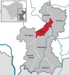  | ||
| Coordinates: 49°17′N 7°14′E / 49.283°N 7.233°ECoordinates: 49°17′N 7°14′E / 49.283°N 7.233°E | ||
| Country | Germany | |
| State | Saarland | |
| District | Saarpfalz | |
| Government | ||
| • Mayor | Frank John (SPD) | |
| Area | ||
| • Total | 31.38 km2 (12.12 sq mi) | |
| Elevation | 225-381 m (−1,025 ft) | |
| Population (2017-12-31)[1] | ||
| • Total | 10,065 | |
| • Density | 320/km2 (830/sq mi) | |
| Time zone | CET/CEST (UTC+1/+2) | |
| Postal codes | 66459 | |
| Vehicle registration | HOM | |
| Website | www.kirkel.eu | |

Kirkel is a municipality in the Saarpfalz district, in Saarland, Germany. It is situated approximatively 8 km southeast of Neunkirchen, and 20 km east/northeast of Saarbrücken.
Overview
A rather well-preserved castle ruin is located a few hundred metres from the town centre. The small Kirkel castle was built in 1075 and is the town's landmark. Located on top of a small castle hill, and due to its large tower with 169 steps to the top, it can be seen from a great distance. Kirkel has the densest forest range in whole Saarland region. It attracts many visitors due to its nice picturesque valleys and greenery over the hills. Kirkel celebrates festivals more than any other place in the area. The most famous sight was the "Wurstmarkt" around August, which lasted for five days with a proper beer festival. As of 2014, no more Wurstmarkts are being held in Kirkel.[2]
Associated notable people
- Poet and cabaret artist Günther Hussong was born here in 1948
References
External links
![]()
- Burgsommer auf Burg Kirkel (in German)
- Castle Kirkel (in German)
Towns and municipalities in Saarpfalz | ||
|---|---|---|